Bottenwil geodata
Bottenwil (Aargau) is a populated place; located in Switzerland in Europe/Zurich (GMT+2) time zone. With population of 800 people, there are 1492 cities with bigger population in this country. Compared to other cities in Switzerland, 56.4% of cities are located further ↓South; 60.2% of cities are located further →East and 54.2% of cities have lower elevation than Bottenwil. Note1


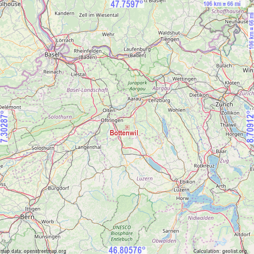
Bottenwil GPS coordinates[2]
47° 17' 5.568" North, 8° 0' 21.564" East
| Map corner | latitude | longitude |
|---|---|---|
| Upper-left | 47.7597°, | 7.30287° |
| Center: | 47.28488°, | 8.00599° |
| Lower-right: | 46.80576°, | 8.70912° |
| Map W x H: | 106.1×106.1 km | = 65.9×65.9mi |
| max Lat: | 47.76737° ⇑43.6% North |
| Bottenwil: | 47.28488° |
| min Lat: | ⇓56.4% South 45.83203° |
| min Long | Bottenwil | max Long |
| 5.97153° | 8.00599° | 10.44624° |
| W 39.8%⇐ | ⇒60.2% E |
Elevation
Elevation of Bottenwil is 492 m = 1614 ft, and this is 66.2 m = 217 ft below average elevation for this country.
| Max E: |
1845 m = 6053 ft | 45.8% |
| Avg. | 558.2 m = 1831 ft | |
| Bottenwil | 492 m = 1614 ft | |
Min E: |
197 m = 646 ft | 54.2% |
See also: Switzerland elevation on elevation.city.
Geographical zone
Bottenwil is located in North temperate zone (between Tropic of Cancer and the Arctic Circle). Distance of this North polar circle is 2143.6 km =1332 mi to North.| Distance of | km | miles | from Bottenwil |
|---|---|---|---|
| North Pole | 4749.5 | 2951.2 | to North |
| Arctic Circle | 2143.6 | 1332 | to North |
| Tropic Cancer | 2651.7 | 1647.7 | to South |
| Equator | 5257.6 | 3266.9 | to South |


Nearby cities:
15 places around Bottenwil: (largest is in red/bold)
• Brittnau
5.3 km =3.3 mi,  237°
237°
• Kirchleerau
4.6 km =2.9 mi,  102°
102°
• Kölliken
5.5 km =3.4 mi,  12°
12°
• Muhen
6.8 km =4.2 mi,  33°
33°
• Oftringen
6.9 km =4.3 mi,  297°
297°
• Reiden
4.9 km =3 mi,  211°
211°
• Safenwil
4.5 km =2.8 mi,  336°
336°
• Schlossrued
6.2 km =3.9 mi,  83°
83°
• Schöftland
4.1 km =2.5 mi,  55°
55°
• Staffelbach
2.7 km =1.7 mi,  92°
92°
• Strengelbach
5.8 km =3.6 mi,  263°
263°
• Uerkheim
2.4 km =1.5 mi, 32°
• Wikon
3.7 km =2.3 mi,  230°
230°
• Winikon
6.3 km =3.9 mi,  149°
149°
• Zofingen
4.5 km =2.8 mi,  274°
274°
Sources, notices
• [Note1] Compared only with cities in Switzerland existing in our database
• [Src1] Map data: © OpenStreetMap contributors (CC-BY-SA)
• [Src2] Other city data from geonames.org with taken over terms of usage.
• [Src3] Geographical zone / Annual Mean Temperature by Robert A. Rohde @ Wikipedia
