Safenwil geodata
Safenwil (Aargau) is a populated place; located in Switzerland in Europe/Zurich (GMT+2) time zone. With population of 3,201 people, there are 553 cities with bigger population in this country. Compared to other cities in Switzerland, 61.3% of cities are located further ↓South; 60.9% of cities are located further →East and 51.4% of cities have higher elevation than Safenwil. Note1


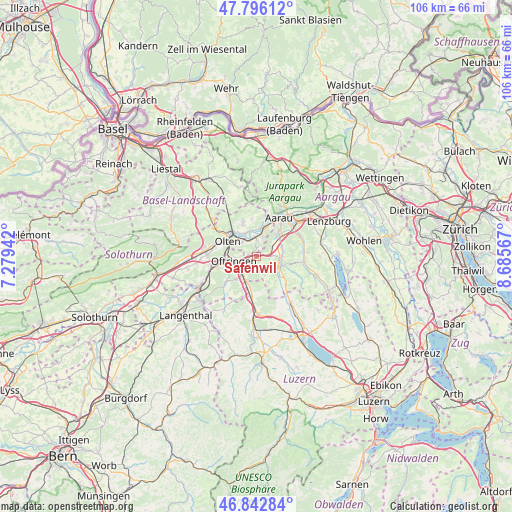
Safenwil GPS coordinates[2]
47° 19' 17.868" North, 7° 58' 57.144" East
| Map corner | latitude | longitude |
|---|---|---|
| Upper-left | 47.79612°, | 7.27942° |
| Center: | 47.32163°, | 7.98254° |
| Lower-right: | 46.84284°, | 8.68567° |
| Map W x H: | 106×106 km | = 65.9×65.9mi |
| max Lat: | 47.76737° ⇑38.7% North |
| Safenwil: | 47.32163° |
| min Lat: | ⇓61.3% South 45.83203° |
| min Long | Safenwil | max Long |
| 5.97153° | 7.98254° | 10.44624° |
| W 39.1%⇐ | ⇒60.9% E |
Elevation
Elevation of Safenwil is 475 m = 1558 ft, and this is 83.2 m = 273 ft below average elevation for this country.
| Max E: |
1845 m = 6053 ft | 51.4% |
| Avg. | 558.2 m = 1831 ft | |
| Safenwil | 475 m = 1558 ft | |
Min E: |
197 m = 646 ft | 48.6% |
See also: Switzerland elevation on elevation.city.
Geographical zone
Safenwil is located in North temperate zone (between Tropic of Cancer and the Arctic Circle). Distance of this North polar circle is 2139.5 km =1329.4 mi to North.| Distance of | km | miles | from Safenwil |
|---|---|---|---|
| North Pole | 4745.4 | 2948.7 | to North |
| Arctic Circle | 2139.5 | 1329.4 | to North |
| Tropic Cancer | 2655.8 | 1650.2 | to South |
| Equator | 5261.7 | 3269.5 | to South |


Nearby cities:
15 places around Safenwil: (largest is in red/bold)
• Aarburg
6.2 km =3.9 mi,  269°
269°
• Bottenwil
4.5 km =2.8 mi,  156°
156°
• Kölliken
3.3 km =2.1 mi,  66°
66°
• Muhen
5.7 km =3.5 mi, 74°
• Niedergösgen
5.6 km =3.5 mi,  4°
4°
• Oberentfelden
6.1 km =3.8 mi,  51°
51°
• Obergösgen
5.4 km =3.4 mi,  334°
334°
• Oftringen
4.4 km =2.7 mi,  258°
258°
• Schöftland
5.5 km =3.4 mi,  108°
108°
• Schönenwerd
5.5 km =3.4 mi,  15°
15°
• Staffelbach
6.1 km =3.8 mi,  133°
133°
• Strengelbach
6.2 km =3.9 mi,  220°
220°
• Uerkheim
3.7 km =2.3 mi,  123°
123°
• Wikon
6.6 km =4.1 mi,  189°
189°
• Zofingen
4.7 km =2.9 mi, 216°
Sources, notices
• [Note1] Compared only with cities in Switzerland existing in our database
• [Src1] Map data: © OpenStreetMap contributors (CC-BY-SA)
• [Src2] Other city data from geonames.org with taken over terms of usage.
• [Src3] Geographical zone / Annual Mean Temperature by Robert A. Rohde @ Wikipedia
