Brittnau geodata
Brittnau (Aargau) is a populated place; located in Switzerland in Europe/Zurich (GMT+2) time zone. With population of 3,735 people, there are 475 cities with bigger population in this country. Compared to other cities in Switzerland, 52.9% of cities are located further ↓South; 61.4% of cities are located further →East and 61.5% of cities have higher elevation than Brittnau. Note1


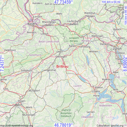
Brittnau GPS coordinates[2]
47° 15' 34.344" North, 7° 56' 48.804" East
| Map corner | latitude | longitude |
|---|---|---|
| Upper-left | 47.73459°, | 7.24377° |
| Center: | 47.25954°, | 7.94689° |
| Lower-right: | 46.78019°, | 8.65002° |
| Map W x H: | 106.1×106.1 km | = 65.9×65.9mi |
| max Lat: | 47.76737° ⇑47.1% North |
| Brittnau: | 47.25954° |
| min Lat: | ⇓52.9% South 45.83203° |
| min Long | Brittnau | max Long |
| 5.97153° | 7.94689° | 10.44624° |
| W 38.6%⇐ | ⇒61.4% E |
Elevation
Elevation of Brittnau is 452 m = 1483 ft, and this is 106.2 m = 348 ft below average elevation for this country.
| Max E: |
1845 m = 6053 ft | 61.5% |
| Avg. | 558.2 m = 1831 ft | |
| Brittnau | 452 m = 1483 ft | |
Min E: |
197 m = 646 ft | 38.5% |
See also: Switzerland elevation on elevation.city.
Geographical zone
Brittnau is located in North temperate zone (between Tropic of Cancer and the Arctic Circle). Distance of this North polar circle is 2146.4 km =1333.7 mi to North.| Distance of | km | miles | from Brittnau |
|---|---|---|---|
| North Pole | 4752.3 | 2952.9 | to North |
| Arctic Circle | 2146.4 | 1333.7 | to North |
| Tropic Cancer | 2648.8 | 1645.9 | to South |
| Equator | 5254.8 | 3265.2 | to South |


Nearby cities:
15 places around Brittnau: (largest is in red/bold)
• Altishofen
6.9 km =4.3 mi,  165°
165°
• Bottenwil
5.3 km =3.3 mi,  57°
57°
• Dagmersellen
5.8 km =3.6 mi,  150°
150°
• Oftringen
6.3 km =3.9 mi,  344°
344°
• Pfaffnau
5.2 km =3.2 mi,  226°
226°
• Reiden
2.3 km =1.4 mi,  126°
126°
• Richenthal
4.7 km =2.9 mi,  182°
182°
• Rothrist
6.5 km =4 mi,  320°
320°
• Safenwil
7.4 km =4.6 mi,  21°
21°
• Strengelbach
2.6 km =1.6 mi,  328°
328°
• Uerkheim
7.6 km =4.7 mi,  49°
49°
• Uffikon
7.6 km =4.7 mi,  135°
135°
• Vordemwald
3.9 km =2.4 mi,  297°
297°
• Wikon
1.7 km =1.1 mi,  74°
74°
• Zofingen
3.1 km =1.9 mi,  358°
358°
Sources, notices
• [Note1] Compared only with cities in Switzerland existing in our database
• [Src1] Map data: © OpenStreetMap contributors (CC-BY-SA)
• [Src2] Other city data from geonames.org with taken over terms of usage.
• [Src3] Geographical zone / Annual Mean Temperature by Robert A. Rohde @ Wikipedia
