Zofingen geodata
Zofingen (Aargau) is a seat of a second-order administrative division; located in Switzerland in Europe/Zurich (GMT+2) time zone. With population of 11,451 people, there are 118 cities with bigger population in this country. Compared to other cities in Switzerland, 56.8% of cities are located further ↓South; 61.5% of cities are located further →East and 67.9% of cities have higher elevation than Zofingen. Note1


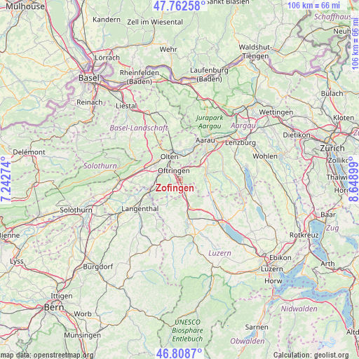
Zofingen GPS coordinates[2]
47° 17' 16.044" North, 7° 56' 45.096" East
| Map corner | latitude | longitude |
|---|---|---|
| Upper-left | 47.76258°, | 7.24274° |
| Center: | 47.28779°, | 7.94586° |
| Lower-right: | 46.8087°, | 8.64899° |
| Map W x H: | 106.1×106.1 km | = 65.9×65.9mi |
| max Lat: | 47.76737° ⇑43.2% North |
| Zofingen: | 47.28779° |
| min Lat: | ⇓56.8% South 45.83203° |
| min Long | Zofingen | max Long |
| 5.97153° | 7.94586° | 10.44624° |
| W 38.5%⇐ | ⇒61.5% E |
Elevation
Elevation of Zofingen is 441 m = 1447 ft, and this is 117.2 m = 385 ft below average elevation for this country.
| Max E: |
1845 m = 6053 ft | 67.9% |
| Avg. | 558.2 m = 1831 ft | |
| Zofingen | 441 m = 1447 ft | |
Min E: |
197 m = 646 ft | 32.1% |
See also: Switzerland elevation on elevation.city.
Geographical zone
Zofingen is located in North temperate zone (between Tropic of Cancer and the Arctic Circle). Distance of this North polar circle is 2143.3 km =1331.8 mi to North.| Distance of | km | miles | from Zofingen |
|---|---|---|---|
| North Pole | 4749.2 | 2951 | to North |
| Arctic Circle | 2143.3 | 1331.8 | to North |
| Tropic Cancer | 2652 | 1647.9 | to South |
| Equator | 5257.9 | 3267.1 | to South |


Nearby cities:
15 places around Zofingen: (largest is in red/bold)
• Aarburg
5 km =3.1 mi,  316°
316°
• Bottenwil
4.5 km =2.8 mi,  94°
94°
• Brittnau
3.1 km =1.9 mi,  178°
178°
• Kölliken
7.7 km =4.8 mi,  48°
48°
• Oftringen
3.3 km =2.1 mi,  331°
331°
• Olten
7.6 km =4.7 mi,  335°
335°
• Pfaffnau
7.6 km =4.7 mi,  208°
208°
• Reiden
4.9 km =3 mi,  156°
156°
• Rothrist
4.5 km =2.8 mi,  295°
295°
• Safenwil
4.7 km =2.9 mi,  36°
36°
• Staffelbach
7.3 km =4.5 mi, 93°
• Strengelbach
1.6 km =1 mi,  233°
233°
• Uerkheim
6.1 km =3.8 mi,  73°
73°
• Vordemwald
3.6 km =2.2 mi,  248°
248°
• Wikon
3.2 km =2 mi,  148°
148°
Sources, notices
• [Note1] Compared only with cities in Switzerland existing in our database
• [Src1] Map data: © OpenStreetMap contributors (CC-BY-SA)
• [Src2] Other city data from geonames.org with taken over terms of usage.
• [Src3] Geographical zone / Annual Mean Temperature by Robert A. Rohde @ Wikipedia
