Birsfelden geodata
Birsfelden (Basel-Landschaft) is a populated place; located in Switzerland in Europe/Zurich (GMT+2) time zone. With population of 10,232 people, there are 143 cities with bigger population in this country. Compared to other cities in Switzerland, 95.1% of cities are located further ↓South; 70.7% of cities are located further →East and 98.9% of cities have higher elevation than Birsfelden. Note1


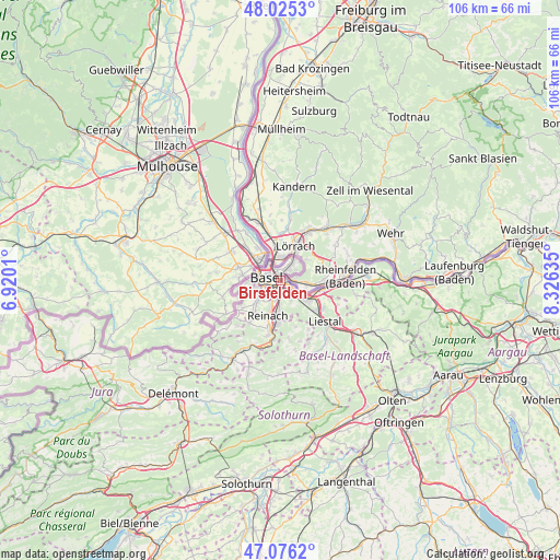
Birsfelden GPS coordinates[2]
47° 33' 10.44" North, 7° 37' 23.592" East
| Map corner | latitude | longitude |
|---|---|---|
| Upper-left | 48.0253°, | 6.9201° |
| Center: | 47.5529°, | 7.62322° |
| Lower-right: | 47.0762°, | 8.32635° |
| Map W x H: | 105.5×105.5 km | = 65.6×65.6mi |
| max Lat: | 47.76737° ⇑4.9% North |
| Birsfelden: | 47.5529° |
| min Lat: | ⇓95.1% South 45.83203° |
| min Long | Birsfelden | max Long |
| 5.97153° | 7.62322° | 10.44624° |
| W 29.3%⇐ | ⇒70.7% E |
Elevation
Elevation of Birsfelden is 259 m = 850 ft, and this is 299.2 m = 982 ft below average elevation for this country.
| Max E: |
1845 m = 6053 ft | 98.9% |
| Avg. | 558.2 m = 1831 ft | |
| Birsfelden | 259 m = 850 ft | |
Min E: |
197 m = 646 ft | 1.1% |
See also: Switzerland elevation on elevation.city.
Geographical zone
Birsfelden is located in North temperate zone (between Tropic of Cancer and the Arctic Circle). Distance of this North polar circle is 2113.8 km =1313.5 mi to North.| Distance of | km | miles | from Birsfelden |
|---|---|---|---|
| North Pole | 4719.7 | 2932.7 | to North |
| Arctic Circle | 2113.8 | 1313.5 | to North |
| Tropic Cancer | 2681.5 | 1666.2 | to South |
| Equator | 5287.4 | 3285.4 | to South |


Nearby cities:
15 places around Birsfelden: (largest is in red/bold)
• Allschwil
6.6 km =4.1 mi,  267°
267°
• Arlesheim
6.5 km =4 mi,  182°
182°
• Augst
7.1 km =4.4 mi,  105°
105°
• Basel
3.8 km =2.4 mi,  279°
279°
• Bettingen
3.6 km =2.2 mi,  57°
57°
• Binningen
4.3 km =2.7 mi,  250°
250°
• Bottmingen
5 km =3.1 mi,  229°
229°
• Dornach
8.1 km =5 mi, 183°
• Kaiseraugst
7.9 km =4.9 mi,  100°
100°
• Muttenz
3.7 km =2.3 mi,  153°
153°
• Münchenstein
4 km =2.5 mi,  194°
194°
• Oberwil
6.5 km =4 mi, 228°
• Pratteln
6.4 km =4 mi,  124°
124°
• Riehen
3.4 km =2.1 mi,  31°
31°
• Therwil
7.8 km =4.8 mi,  220°
220°
Sources, notices
• [Note1] Compared only with cities in Switzerland existing in our database
• [Src1] Map data: © OpenStreetMap contributors (CC-BY-SA)
• [Src2] Other city data from geonames.org with taken over terms of usage.
• [Src3] Geographical zone / Annual Mean Temperature by Robert A. Rohde @ Wikipedia
