Allschwil geodata
Allschwil (Basel-Landschaft) is a populated place; located in Switzerland in Europe/Zurich (GMT+2) time zone. With population of 18,189 people, there are 47 cities with bigger population in this country. Compared to other cities in Switzerland, 95% of cities are located further ↓South; 74.5% of cities are located further →East and 97.9% of cities have higher elevation than Allschwil. Note1


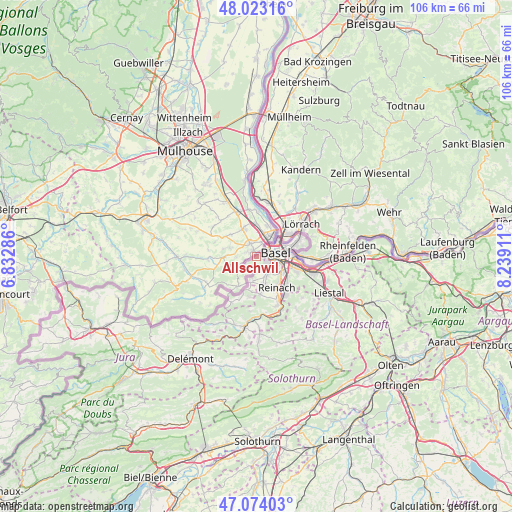
Allschwil GPS coordinates[2]
47° 33' 2.664" North, 7° 32' 9.564" East
| Map corner | latitude | longitude |
|---|---|---|
| Upper-left | 48.02316°, | 6.83286° |
| Center: | 47.55074°, | 7.53599° |
| Lower-right: | 47.07403°, | 8.23911° |
| Map W x H: | 105.5×105.5 km | = 65.6×65.6mi |
| max Lat: | 47.76737° ⇑5% North |
| Allschwil: | 47.55074° |
| min Lat: | ⇓95% South 45.83203° |
| min Long | Allschwil | max Long |
| 5.97153° | 7.53599° | 10.44624° |
| W 25.5%⇐ | ⇒74.5% E |
Elevation
Elevation of Allschwil is 288 m = 945 ft, and this is 270.2 m = 886 ft below average elevation for this country.
| Max E: |
1845 m = 6053 ft | 97.9% |
| Avg. | 558.2 m = 1831 ft | |
| Allschwil | 288 m = 945 ft | |
Min E: |
197 m = 646 ft | 2.1% |
See also: Switzerland elevation on elevation.city.
Geographical zone
Allschwil is located in North temperate zone (between Tropic of Cancer and the Arctic Circle). Distance of this North polar circle is 2114 km =1313.6 mi to North.| Distance of | km | miles | from Allschwil |
|---|---|---|---|
| North Pole | 4719.9 | 2932.8 | to North |
| Arctic Circle | 2114 | 1313.6 | to North |
| Tropic Cancer | 2681.2 | 1666 | to South |
| Equator | 5287.1 | 3285.3 | to South |


Nearby cities:
15 places around Allschwil: (largest is in red/bold)
• Arlesheim
8.9 km =5.5 mi,  135°
135°
• Basel
2.9 km =1.8 mi,  73°
73°
• Bettingen
9.9 km =6.2 mi,  77°
77°
• Binningen
2.8 km =1.7 mi,  115°
115°
• Birsfelden
6.6 km =4.1 mi,  87°
87°
• Bottmingen
4.1 km =2.5 mi, 138°
• Dornach
9.9 km =6.2 mi, 142°
• Ettingen
7.7 km =4.8 mi,  174°
174°
• Muttenz
8.8 km =5.5 mi,  110°
110°
• Münchenstein
6.6 km =4.1 mi, 122°
• Oberwil
4.4 km =2.7 mi,  158°
158°
• Riehen
8.9 km =5.5 mi, 69°
• Rodersdorf
9.7 km =6 mi,  217°
217°
• Schönenbuch
2.6 km =1.6 mi,  239°
239°
• Therwil
5.9 km =3.7 mi, 164°
Sources, notices
• [Note1] Compared only with cities in Switzerland existing in our database
• [Src1] Map data: © OpenStreetMap contributors (CC-BY-SA)
• [Src2] Other city data from geonames.org with taken over terms of usage.
• [Src3] Geographical zone / Annual Mean Temperature by Robert A. Rohde @ Wikipedia
