Arlesheim geodata
Arlesheim (Basel-Landschaft) is a seat of a second-order administrative division; located in Switzerland in Europe/Zurich (GMT+2) time zone. With population of 9,301 people, there are 168 cities with bigger population in this country. Compared to other cities in Switzerland, 88% of cities are located further ↓South; 71% of cities are located further →East and 96.2% of cities have higher elevation than Arlesheim. Note1


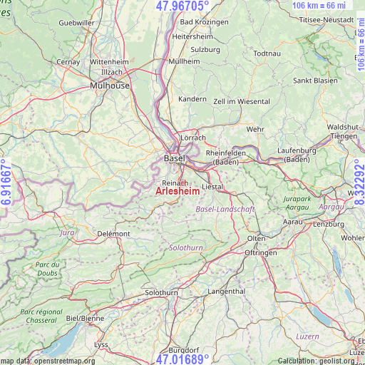
Arlesheim GPS coordinates[2]
47° 29' 38.832" North, 7° 37' 11.244" East
| Map corner | latitude | longitude |
|---|---|---|
| Upper-left | 47.96705°, | 6.91667° |
| Center: | 47.49412°, | 7.61979° |
| Lower-right: | 47.01689°, | 8.32292° |
| Map W x H: | 105.6×105.6 km | = 65.6×65.6mi |
| max Lat: | 47.76737° ⇑12% North |
| Arlesheim: | 47.49412° |
| min Lat: | ⇓88% South 45.83203° |
| min Long | Arlesheim | max Long |
| 5.97153° | 7.61979° | 10.44624° |
| W 29%⇐ | ⇒71% E |
Elevation
Elevation of Arlesheim is 332 m = 1089 ft, and this is 226.2 m = 742 ft below average elevation for this country.
| Max E: |
1845 m = 6053 ft | 96.2% |
| Avg. | 558.2 m = 1831 ft | |
| Arlesheim | 332 m = 1089 ft | |
Min E: |
197 m = 646 ft | 3.8% |
See also: Switzerland elevation on elevation.city.
Geographical zone
Arlesheim is located in North temperate zone (between Tropic of Cancer and the Arctic Circle). Distance of this North polar circle is 2120.3 km =1317.5 mi to North.| Distance of | km | miles | from Arlesheim |
|---|---|---|---|
| North Pole | 4726.2 | 2936.7 | to North |
| Arctic Circle | 2120.3 | 1317.5 | to North |
| Tropic Cancer | 2674.9 | 1662.1 | to South |
| Equator | 5280.9 | 3281.4 | to South |


Nearby cities:
15 places around Arlesheim: (largest is in red/bold)
• Aesch
3.1 km =1.9 mi,  213°
213°
• Binningen
6.4 km =4 mi,  323°
323°
• Birsfelden
6.5 km =4 mi,  2°
2°
• Bottmingen
4.8 km =3 mi,  312°
312°
• Dornach
1.5 km =0.9 mi,  189°
189°
• Ettingen
5.7 km =3.5 mi,  256°
256°
• Gempen
3.7 km =2.3 mi,  123°
123°
• Grellingen
6.2 km =3.9 mi,  201°
201°
• Hochwald
4.8 km =3 mi,  157°
157°
• Muttenz
3.7 km =2.3 mi,  30°
30°
• Münchenstein
2.8 km =1.7 mi,  344°
344°
• Oberwil
5.2 km =3.2 mi,  295°
295°
• Pfeffingen
4.4 km =2.7 mi, 210°
• Pratteln
6.3 km =3.9 mi,  61°
61°
• Therwil
4.8 km =3 mi,  277°
277°
Sources, notices
• [Note1] Compared only with cities in Switzerland existing in our database
• [Src1] Map data: © OpenStreetMap contributors (CC-BY-SA)
• [Src2] Other city data from geonames.org with taken over terms of usage.
• [Src3] Geographical zone / Annual Mean Temperature by Robert A. Rohde @ Wikipedia
