Ballwil geodata
Ballwil (Lucerne) is a populated place; located in Switzerland in Europe/Zurich (GMT+2) time zone. With population of 2,284 people, there are 747 cities with bigger population in this country. Compared to other cities in Switzerland, 55.9% of cities are located further ↑North; 52.6% of cities are located further →East and 56.2% of cities have lower elevation than Ballwil. Note1


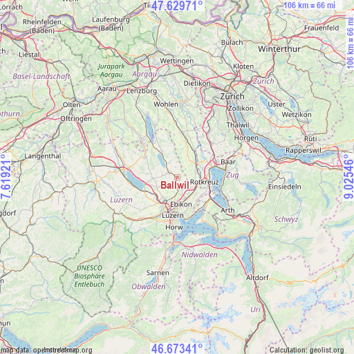
Ballwil GPS coordinates[2]
47° 9' 13.356" North, 8° 19' 20.388" East
| Map corner | latitude | longitude |
|---|---|---|
| Upper-left | 47.62971°, | 7.61921° |
| Center: | 47.15371°, | 8.32233° |
| Lower-right: | 46.67341°, | 9.02546° |
| Map W x H: | 106.3×106.3 km | = 66.1×66.1mi |
| max Lat: | 47.76737° ⇑55.9% North |
| Ballwil: | 47.15371° |
| min Lat: | ⇓44.1% South 45.83203° |
| min Long | Ballwil | max Long |
| 5.97153° | 8.32233° | 10.44624° |
| W 47.4%⇐ | ⇒52.6% E |
Elevation
Elevation of Ballwil is 502 m = 1647 ft, and this is 56.2 m = 184 ft below average elevation for this country.
| Max E: |
1845 m = 6053 ft | 43.8% |
| Avg. | 558.2 m = 1831 ft | |
| Ballwil | 502 m = 1647 ft | |
Min E: |
197 m = 646 ft | 56.2% |
See also: Switzerland elevation on elevation.city.
Geographical zone
Ballwil is located in North temperate zone (between Tropic of Cancer and the Arctic Circle). Distance of this North polar circle is 2158.2 km =1341 mi to North.| Distance of | km | miles | from Ballwil |
|---|---|---|---|
| North Pole | 4764.1 | 2960.3 | to North |
| Arctic Circle | 2158.2 | 1341 | to North |
| Tropic Cancer | 2637.1 | 1638.6 | to South |
| Equator | 5243 | 3257.8 | to South |


Nearby cities:
15 places around Ballwil: (largest is in red/bold)
• Auw
7.2 km =4.5 mi,  27°
27°
• Buchrain
6.7 km =4.2 mi,  163°
163°
• Dietwil
5.4 km =3.4 mi,  98°
98°
• Ebikon
8.4 km =5.2 mi,  170°
170°
• Gelfingen
8 km =5 mi,  327°
327°
• Hildisrieden
7.3 km =4.5 mi,  267°
267°
• Hochdorf
2.8 km =1.7 mi,  305°
305°
• Hohenrain
3 km =1.9 mi,  353°
353°
• Hünenberg
8.1 km =5 mi,  72°
72°
• Inwil
3.7 km =2.3 mi,  147°
147°
• Oberrüti
5.6 km =3.5 mi,  75°
75°
• Root
6.7 km =4.2 mi,  130°
130°
• Rotkreuz
8.3 km =5.2 mi, 98°
• Römerswil
6.1 km =3.8 mi,  286°
286°
• Sins
6.9 km =4.3 mi,  51°
51°
Sources, notices
• [Note1] Compared only with cities in Switzerland existing in our database
• [Src1] Map data: © OpenStreetMap contributors (CC-BY-SA)
• [Src2] Other city data from geonames.org with taken over terms of usage.
• [Src3] Geographical zone / Annual Mean Temperature by Robert A. Rohde @ Wikipedia
