Sins geodata
Sins (Aargau) is a populated place; located in Switzerland in Europe/Zurich (GMT+2) time zone. With population of 3,600 people, there are 496 cities with bigger population in this country. Compared to other cities in Switzerland, 53.3% of cities are located further ↑North; 50.7% of cities are located further →East and 78.4% of cities have higher elevation than Sins. Note1


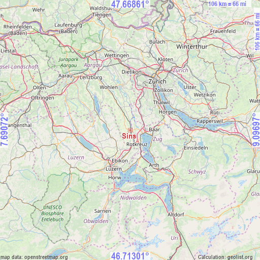
Sins GPS coordinates[2]
47° 11' 34.656" North, 8° 23' 37.824" East
| Map corner | latitude | longitude |
|---|---|---|
| Upper-left | 47.66861°, | 7.69072° |
| Center: | 47.19296°, | 8.39384° |
| Lower-right: | 46.71301°, | 9.09697° |
| Map W x H: | 106.3×106.3 km | = 66.1×66.1mi |
| max Lat: | 47.76737° ⇑53.3% North |
| Sins: | 47.19296° |
| min Lat: | ⇓46.7% South 45.83203° |
| min Long | Sins | max Long |
| 5.97153° | 8.39384° | 10.44624° |
| W 49.3%⇐ | ⇒50.7% E |
Elevation
Elevation of Sins is 425 m = 1394 ft, and this is 133.2 m = 437 ft below average elevation for this country.
| Max E: |
1845 m = 6053 ft | 78.4% |
| Avg. | 558.2 m = 1831 ft | |
| Sins | 425 m = 1394 ft | |
Min E: |
197 m = 646 ft | 21.6% |
See also: Switzerland elevation on elevation.city.
Geographical zone
Sins is located in North temperate zone (between Tropic of Cancer and the Arctic Circle). Distance of this North polar circle is 2153.8 km =1338.3 mi to North.| Distance of | km | miles | from Sins |
|---|---|---|---|
| North Pole | 4759.7 | 2957.5 | to North |
| Arctic Circle | 2153.8 | 1338.3 | to North |
| Tropic Cancer | 2641.4 | 1641.3 | to South |
| Equator | 5247.4 | 3260.6 | to South |


Nearby cities:
15 places around Sins: (largest is in red/bold)
• Auw
2.9 km =1.8 mi,  313°
313°
• Ballwil
6.9 km =4.3 mi,  231°
231°
• Cham
5.4 km =3.4 mi,  102°
102°
• Dietwil
5.1 km =3.2 mi,  180°
180°
• Hohenrain
5.9 km =3.7 mi,  256°
256°
• Hünenberg
3.1 km =1.9 mi,  129°
129°
• Knonau
6.2 km =3.9 mi,  56°
56°
• Merenschwand
7.5 km =4.7 mi,  349°
349°
• Mettmenstetten
7.8 km =4.8 mi,  42°
42°
• Mühlau
4 km =2.5 mi, 354°
• Oberrüti
2.9 km =1.8 mi, 179°
• Obfelden
8.2 km =5.1 mi,  14°
14°
• Obfelden / Oberlunnern
7.9 km =4.9 mi, 12°
• Rotkreuz
6.3 km =3.9 mi,  153°
153°
• Steinhausen
7 km =4.3 mi,  88°
88°
Sources, notices
• [Note1] Compared only with cities in Switzerland existing in our database
• [Src1] Map data: © OpenStreetMap contributors (CC-BY-SA)
• [Src2] Other city data from geonames.org with taken over terms of usage.
• [Src3] Geographical zone / Annual Mean Temperature by Robert A. Rohde @ Wikipedia
