Grellingen geodata
Grellingen (Basel-Landschaft) is a populated place; located in Switzerland in Europe/Zurich (GMT+2) time zone. With population of 1,767 people, there are 917 cities with bigger population in this country. Compared to other cities in Switzerland, 81% of cities are located further ↓South; 72% of cities are located further →East and 96.1% of cities have higher elevation than Grellingen. Note1


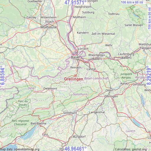
Grellingen GPS coordinates[2]
47° 26' 32.316" North, 7° 35' 20.616" East
| Map corner | latitude | longitude |
|---|---|---|
| Upper-left | 47.91571°, | 6.88594° |
| Center: | 47.44231°, | 7.58906° |
| Lower-right: | 46.96461°, | 8.29219° |
| Map W x H: | 105.8×105.8 km | = 65.7×65.7mi |
| max Lat: | 47.76737° ⇑19% North |
| Grellingen: | 47.44231° |
| min Lat: | ⇓81% South 45.83203° |
| min Long | Grellingen | max Long |
| 5.97153° | 7.58906° | 10.44624° |
| W 28%⇐ | ⇒72% E |
Elevation
Elevation of Grellingen is 334 m = 1096 ft, and this is 224.2 m = 736 ft below average elevation for this country.
| Max E: |
1845 m = 6053 ft | 96.1% |
| Avg. | 558.2 m = 1831 ft | |
| Grellingen | 334 m = 1096 ft | |
Min E: |
197 m = 646 ft | 3.9% |
See also: Switzerland elevation on elevation.city.
Geographical zone
Grellingen is located in North temperate zone (between Tropic of Cancer and the Arctic Circle). Distance of this North polar circle is 2126.1 km =1321.1 mi to North.| Distance of | km | miles | from Grellingen |
|---|---|---|---|
| North Pole | 4732 | 2940.3 | to North |
| Arctic Circle | 2126.1 | 1321.1 | to North |
| Tropic Cancer | 2669.2 | 1658.6 | to South |
| Equator | 5275.1 | 3277.8 | to South |


Nearby cities:
15 places around Grellingen: (largest is in red/bold)
• Aesch
3.3 km =2.1 mi,  10°
10°
• Arlesheim
6.2 km =3.9 mi,  21°
21°
• Blauen
5.3 km =3.3 mi,  279°
279°
• Breitenbach
5.1 km =3.2 mi,  219°
219°
• Brislach
4.4 km =2.7 mi,  231°
231°
• Büsserach
6.5 km =4 mi,  213°
213°
• Dornach
4.7 km =2.9 mi,  25°
25°
• Ettingen
5.5 km =3.4 mi,  324°
324°
• Gempen
6.5 km =4 mi,  55°
55°
• Himmelried
2.5 km =1.6 mi,  160°
160°
• Hochwald
4.4 km =2.7 mi,  72°
72°
• Nunningen
5.8 km =3.6 mi, 156°
• Pfeffingen
1.9 km =1.2 mi,  1°
1°
• Zullwil
5.8 km =3.6 mi,  171°
171°
• Zwingen
4.4 km =2.7 mi,  264°
264°
Sources, notices
• [Note1] Compared only with cities in Switzerland existing in our database
• [Src1] Map data: © OpenStreetMap contributors (CC-BY-SA)
• [Src2] Other city data from geonames.org with taken over terms of usage.
• [Src3] Geographical zone / Annual Mean Temperature by Robert A. Rohde @ Wikipedia
