Affoltern / Sonnenberg geodata
Affoltern / Sonnenberg (Zurich) is a section of populated place; located in Switzerland in Europe/Zurich (GMT+2) time zone. With population of 1,262 people, there are 1157 cities with bigger population in this country. Compared to other cities in Switzerland, 56% of cities are located further ↓South; 53.9% of cities are located further ←West and 65.1% of cities have lower elevation than Affoltern / Sonnenberg. Note1
Current local time in Affoltern / Sonnenberg:
07:41 AM, SaturdayDifference from your time zone: hours


Affoltern / Sonnenberg GPS coordinates[2]
47° 16' 49.98" North, 8° 27' 36.288" East
| Map corner | latitude | longitude |
|---|---|---|
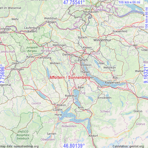
| Upper-left | 47.75541°, | 7.75696° |
| Center: | 47.28055°, | 8.46008° |
| Lower-right: | 46.80139°, | 9.16321° |
| Map W x H: | 106.1×106.1 km | = 65.9×65.9mi |
| max Lat: | 47.76737° ⇑44% North |
| Affoltern / Sonnenberg: | 47.28055° |
| min Lat: | ⇓56% South 45.83203° |
| min Long | Affoltern / Son | max Long |
| 5.97153° | 8.46008° | 10.44624° |
| W 53.9%⇐ | ⇒46.1% E |
Elevation
Elevation of Affoltern / Sonnenberg is 547 m = 1795 ft, and this is 11.2 m = 37 ft below average elevation for this country.
| Max E: |
1845 m = 6053 ft | 34.9% |
| Avg. | 558.2 m = 1831 ft | |
| Affoltern / Sonnenberg | 547 m = 1795 ft | |
Min E: |
197 m = 646 ft | 65.1% |
See also: Switzerland elevation on elevation.city.
Geographical zone
Affoltern / Sonnenberg is located in North temperate zone (between Tropic of Cancer and the Arctic Circle). Distance of this North polar circle is 2144.1 km =1332.3 mi to North.| Distance of | km | miles | from Affoltern / Sonnenberg |
|---|---|---|---|
| North Pole | 4750 | 2951.5 | to North |
| Arctic Circle | 2144.1 | 1332.3 | to North |
| Tropic Cancer | 2651.2 | 1647.4 | to South |
| Equator | 5257.1 | 3266.6 | to South |


Nearby cities:
15 places around Affoltern / Sonnenberg: (largest is in red/bold)
• Aeugst / Aeugst (Dorf)
2.3 km =1.4 mi,  123°
123°
• Aeugst am Albis
2.4 km =1.5 mi,  128°
128°
• Affoltern / Butzen
0.5 km =0.3 mi,  205°
205°
• Affoltern / Goldiger Berg
1.2 km =0.7 mi,  258°
258°
• Affoltern / Hasenbüel
1 km =0.6 mi,  216°
216°
• Affoltern / Oberdorf
0.4 km =0.2 mi,  230°
230°
• Affoltern / Unterdorf
0.5 km =0.3 mi,  298°
298°
• Affoltern am Albis
0.7 km =0.4 mi,  242°
242°
• Bonstetten
3.9 km =2.4 mi,  9°
9°
• Hedingen
2.1 km =1.3 mi,  335°
335°
• Mettmenstetten
3.9 km =2.4 mi,  176°
176°
• Obfelden
3.4 km =2.1 mi, 237°
• Obfelden / Bickwil
3 km =1.9 mi,  245°
245°
• Obfelden / Toussen
2.8 km =1.7 mi, 233°
• Zwillikon
2.3 km =1.4 mi,  291°
291°
Sources, notices
• [Note1] Compared only with cities in Switzerland existing in our database
• [Src1] Map data: © OpenStreetMap contributors (CC-BY-SA)
• [Src2] Other city data from geonames.org with taken over terms of usage.
• [Src3] Geographical zone / Annual Mean Temperature by Robert A. Rohde @ Wikipedia
