Zwillikon geodata
Zwillikon (Zurich) is a populated place; located in Switzerland in Europe/Zurich (GMT+2) time zone. With population of 620 people, there are 1673 cities with bigger population in this country. Compared to other cities in Switzerland, 56.8% of cities are located further ↓South; 51.8% of cities are located further ←West and 56% of cities have higher elevation than Zwillikon. Note1


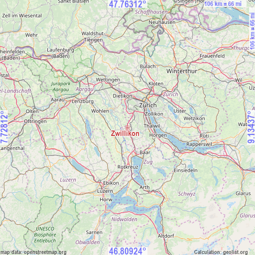
Zwillikon GPS coordinates[2]
47° 17' 17.988" North, 8° 25' 52.464" East
| Map corner | latitude | longitude |
|---|---|---|
| Upper-left | 47.76312°, | 7.72812° |
| Center: | 47.28833°, | 8.43124° |
| Lower-right: | 46.80924°, | 9.13437° |
| Map W x H: | 106.1×106.1 km | = 65.9×65.9mi |
| max Lat: | 47.76737° ⇑43.2% North |
| Zwillikon: | 47.28833° |
| min Lat: | ⇓56.8% South 45.83203° |
| min Long | Zwillikon | max Long |
| 5.97153° | 8.43124° | 10.44624° |
| W 51.8%⇐ | ⇒48.2% E |
Elevation
Elevation of Zwillikon is 465 m = 1526 ft, and this is 93.2 m = 306 ft below average elevation for this country.
| Max E: |
1845 m = 6053 ft | 56% |
| Avg. | 558.2 m = 1831 ft | |
| Zwillikon | 465 m = 1526 ft | |
Min E: |
197 m = 646 ft | 44% |
See also: Switzerland elevation on elevation.city.
Geographical zone
Zwillikon is located in North temperate zone (between Tropic of Cancer and the Arctic Circle). Distance of this North polar circle is 2143.2 km =1331.7 mi to North.| Distance of | km | miles | from Zwillikon |
|---|---|---|---|
| North Pole | 4749.1 | 2951 | to North |
| Arctic Circle | 2143.2 | 1331.7 | to North |
| Tropic Cancer | 2652.1 | 1647.9 | to South |
| Equator | 5258 | 3267.2 | to South |


Nearby cities:
15 places around Zwillikon: (largest is in red/bold)
• Affoltern / Butzen
2.4 km =1.5 mi,  123°
123°
• Affoltern / Goldiger Berg
1.5 km =0.9 mi,  136°
136°
• Affoltern / Hasenbüel
2.3 km =1.4 mi, 136°
• Affoltern / Oberdorf
2.2 km =1.4 mi, 119°
• Affoltern / Sonnenberg
2.3 km =1.4 mi,  111°
111°
• Affoltern / Unterdorf
1.8 km =1.1 mi, 109°
• Affoltern am Albis
1.9 km =1.2 mi,  128°
128°
• Hedingen
1.7 km =1.1 mi,  50°
50°
• Jonen
3.1 km =1.9 mi,  289°
289°
• Oberlunkhofen
4 km =2.5 mi,  312°
312°
• Obfelden
2.8 km =1.7 mi,  195°
195°
• Obfelden / Bickwil
2.2 km =1.4 mi,  193°
193°
• Obfelden / Oberlunnern
3.2 km =2 mi, 201°
• Obfelden / Toussen
2.5 km =1.6 mi,  181°
181°
• Ottenbach
2.1 km =1.3 mi,  251°
251°
Sources, notices
• [Note1] Compared only with cities in Switzerland existing in our database
• [Src1] Map data: © OpenStreetMap contributors (CC-BY-SA)
• [Src2] Other city data from geonames.org with taken over terms of usage.
• [Src3] Geographical zone / Annual Mean Temperature by Robert A. Rohde @ Wikipedia
