Bonstetten geodata
Bonstetten (Zurich) is a populated place; located in Switzerland in Europe/Zurich (GMT+2) time zone. With population of 2,260 people, there are 754 cities with bigger population in this country. Compared to other cities in Switzerland, 60.1% of cities are located further ↓South; 55% of cities are located further ←West and 64.5% of cities have lower elevation than Bonstetten. Note1


Bonstetten GPS coordinates[2]
47° 18' 54.18" North, 8° 28' 6.096" East
| Map corner | latitude | longitude |
|---|---|---|
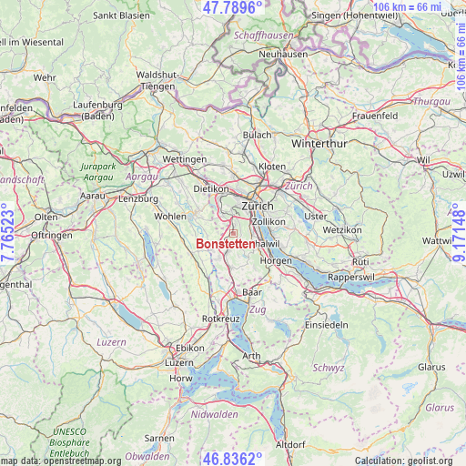
| Upper-left | 47.7896°, | 7.76523° |
| Center: | 47.31505°, | 8.46836° |
| Lower-right: | 46.8362°, | 9.17148° |
| Map W x H: | 106×106 km | = 65.9×65.9mi |
| max Lat: | 47.76737° ⇑39.9% North |
| Bonstetten: | 47.31505° |
| min Lat: | ⇓60.1% South 45.83203° |
| min Long | Bonstetten | max Long |
| 5.97153° | 8.46836° | 10.44624° |
| W 55%⇐ | ⇒45% E |
Elevation
Elevation of Bonstetten is 544 m = 1785 ft, and this is 14.2 m = 47 ft below average elevation for this country.
| Max E: |
1845 m = 6053 ft | 35.5% |
| Avg. | 558.2 m = 1831 ft | |
| Bonstetten | 544 m = 1785 ft | |
Min E: |
197 m = 646 ft | 64.5% |
See also: Switzerland elevation on elevation.city.
Geographical zone
Bonstetten is located in North temperate zone (between Tropic of Cancer and the Arctic Circle). Distance of this North polar circle is 2140.2 km =1329.9 mi to North.| Distance of | km | miles | from Bonstetten |
|---|---|---|---|
| North Pole | 4746.1 | 2949.1 | to North |
| Arctic Circle | 2140.2 | 1329.9 | to North |
| Tropic Cancer | 2655 | 1649.7 | to South |
| Equator | 5260.9 | 3269 | to South |


Nearby cities:
15 places around Bonstetten: (largest is in red/bold)
• Adliswil / Hündli-Zopf
3.8 km =2.4 mi,  87°
87°
• Adliswil / Oberleimbach
3.6 km =2.2 mi,  80°
80°
• Adliswil / Sihlhof
4.1 km =2.5 mi, 78°
• Adliswil / Sonnenberg
4 km =2.5 mi,  98°
98°
• Aesch
3.2 km =2 mi,  319°
319°
• Affoltern / Sonnenberg
3.9 km =2.4 mi,  189°
189°
• Affoltern / Unterdorf
3.7 km =2.3 mi,  196°
196°
• Hedingen
2.4 km =1.5 mi,  218°
218°
• Schachen
1.1 km =0.7 mi,  17°
17°
• Sellenbüren
3.4 km =2.1 mi, 19°
• Wettswil
2.5 km =1.6 mi,  11°
11°
• Wettswil / Ausser-Dorf
2 km =1.2 mi, 19°
• Wettswil / Wettswil (Dorf)
3 km =1.9 mi,  4°
4°
• Zürich (Kreis 2) / Mittel-Leimbach
3.6 km =2.2 mi,  71°
71°
• Zürich (Kreis 2) / Unter-Leimbach
4 km =2.5 mi,  59°
59°
Sources, notices
• [Note1] Compared only with cities in Switzerland existing in our database
• [Src1] Map data: © OpenStreetMap contributors (CC-BY-SA)
• [Src2] Other city data from geonames.org with taken over terms of usage.
• [Src3] Geographical zone / Annual Mean Temperature by Robert A. Rohde @ Wikipedia
