Rümlang / Säntisstrasse-Aegler geodata
Rümlang / Säntisstrasse-Aegler (Zurich) is a section of populated place; located in Switzerland in Europe/Zurich (GMT+2) time zone. With population of 767 people, there are 1517 cities with bigger population in this country. Compared to other cities in Switzerland, 83% of cities are located further ↓South; 59.3% of cities are located further ←West and 61.5% of cities have higher elevation than Rümlang / Säntisstrasse-Aegler. Note1
Current local time in Rümlang / Säntisstrasse-Aegler:
06:20 AM, SaturdayDifference from your time zone: hours


Rümlang / Säntisstrasse-Aegler GPS coordinates[2]
47° 27' 10.296" North, 8° 31' 34.284" East
| Map corner | latitude | longitude |
|---|---|---|
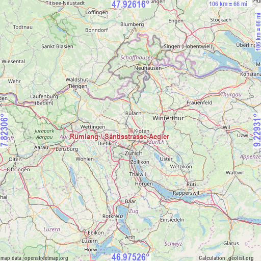
| Upper-left | 47.92616°, | 7.82306° |
| Center: | 47.45286°, | 8.52619° |
| Lower-right: | 46.97526°, | 9.22931° |
| Map W x H: | 105.7×105.7 km | = 65.7×65.7mi |
| max Lat: | 47.76737° ⇑17% North |
| Rümlang / Säntisstrasse-Aegler: | 47.45286° |
| min Lat: | ⇓83% South 45.83203° |
| min Long | Rümlang / Sän | max Long |
| 5.97153° | 8.52619° | 10.44624° |
| W 59.3%⇐ | ⇒40.7% E |
Elevation
Elevation of Rümlang / Säntisstrasse-Aegler is 452 m = 1483 ft, and this is 106.2 m = 348 ft below average elevation for this country.
| Max E: |
1845 m = 6053 ft | 61.5% |
| Avg. | 558.2 m = 1831 ft | |
| Rümlang / Säntisstrasse-Aegler | 452 m = 1483 ft | |
Min E: |
197 m = 646 ft | 38.5% |
See also: Switzerland elevation on elevation.city.
Geographical zone
Rümlang / Säntisstrasse-Aegler is located in North temperate zone (between Tropic of Cancer and the Arctic Circle). Distance of this North polar circle is 2124.9 km =1320.4 mi to North.| Distance of | km | miles | from Rümlang / Säntisstrasse-Aegler |
|---|---|---|---|
| North Pole | 4730.8 | 2939.6 | to North |
| Arctic Circle | 2124.9 | 1320.4 | to North |
| Tropic Cancer | 2670.3 | 1659.2 | to South |
| Equator | 5276.3 | 3278.5 | to South |


Nearby cities:
15 places around Rümlang / Säntisstrasse-Aegler: (largest is in red/bold)
• Glattbrugg
3.6 km =2.2 mi,  131°
131°
• Glattbrugg / Rohr/Platten-Balsberg
3.5 km =2.2 mi,  119°
119°
• Glattbrugg / Zentrum Müllacker
3.8 km =2.4 mi, 122°
• Hofstetten
3.1 km =1.9 mi,  331°
331°
• Kloten / Balsberg
3.8 km =2.4 mi,  107°
107°
• Oberglatt
2.6 km =1.6 mi,  347°
347°
• Oberglatt / Bahnhofquartier
2.3 km =1.4 mi, 334°
• Oberglatt / Bellen-Grafschaft
3 km =1.9 mi,  357°
357°
• Oberglatt / Oberglatt (Dorfkern)
2.6 km =1.6 mi, 348°
• Oberhasli / Birch
2.7 km =1.7 mi,  313°
313°
• Rümlang
0.4 km =0.2 mi, 134°
• Rümlang / Huebacher
0.8 km =0.5 mi,  180°
180°
• Rümlang / Rümlang (Dorfkern)
0.6 km =0.4 mi, 128°
• Zürich (Kreis 11)
3.3 km =2.1 mi,  185°
185°
• Zürich (Kreis 11) / Schwandenholz
3.1 km =1.9 mi, 186°
Sources, notices
• [Note1] Compared only with cities in Switzerland existing in our database
• [Src1] Map data: © OpenStreetMap contributors (CC-BY-SA)
• [Src2] Other city data from geonames.org with taken over terms of usage.
• [Src3] Geographical zone / Annual Mean Temperature by Robert A. Rohde @ Wikipedia
