Uitikon / Waldegg geodata
Uitikon / Waldegg (Zurich) is a section of populated place; located in Switzerland in Europe/Zurich (GMT+2) time zone. With population of 850 people, there are 1455 cities with bigger population in this country. Compared to other cities in Switzerland, 66.4% of cities are located further ↓South; 54.6% of cities are located further ←West and 73.7% of cities have lower elevation than Uitikon / Waldegg. Note1


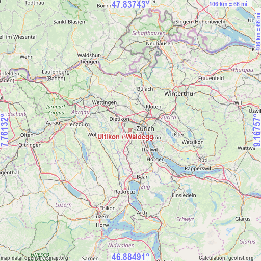
Uitikon / Waldegg GPS coordinates[2]
47° 21' 47.952" North, 8° 27' 51.984" East
| Map corner | latitude | longitude |
|---|---|---|
| Upper-left | 47.83743°, | 7.76132° |
| Center: | 47.36332°, | 8.46444° |
| Lower-right: | 46.88491°, | 9.16757° |
| Map W x H: | 105.9×105.9 km | = 65.8×65.8mi |
| max Lat: | 47.76737° ⇑33.6% North |
| Uitikon / Waldegg: | 47.36332° |
| min Lat: | ⇓66.4% South 45.83203° |
| min Long | Uitikon / Walde | max Long |
| 5.97153° | 8.46444° | 10.44624° |
| W 54.6%⇐ | ⇒45.4% E |
Elevation
Elevation of Uitikon / Waldegg is 604 m = 1982 ft, and this is 45.8 m = 150 ft above average elevation for this country.
| Max E: |
1845 m = 6053 ft | 26.3% |
| Uitikon / Waldegg | 604 m 1982 ft | |
| Avg. | 558.2 m = 1831 ft | |
Min E: |
197 m = 646 ft | 73.7% |
See also: Switzerland elevation on elevation.city.
Geographical zone
Uitikon / Waldegg is located in North temperate zone (between Tropic of Cancer and the Arctic Circle). Distance of this North polar circle is 2134.9 km =1326.6 mi to North.| Distance of | km | miles | from Uitikon / Waldegg |
|---|---|---|---|
| North Pole | 4740.8 | 2945.8 | to North |
| Arctic Circle | 2134.9 | 1326.6 | to North |
| Tropic Cancer | 2660.4 | 1653.1 | to South |
| Equator | 5266.3 | 3272.3 | to South |


Nearby cities:
15 places around Uitikon / Waldegg: (largest is in red/bold)
• Aesch
3.4 km =2.1 mi,  210°
210°
• Birmensdorf
1.9 km =1.2 mi,  241°
241°
• Birmensdorf / Haslen
0.5 km =0.3 mi,  218°
218°
• Sellenbüren
2.6 km =1.6 mi,  147°
147°
• Uitikon
0.9 km =0.6 mi,  318°
318°
• Uitikon / Halde
1.2 km =0.7 mi,  327°
327°
• Uitikon / Uitikon (Dorfkern)
1.2 km =0.7 mi,  313°
313°
• Urdorf / Fadmatt
3.4 km =2.1 mi, 307°
• Wettswil
3 km =1.9 mi,  164°
164°
• Wettswil / Wettswil (Dorf)
2.5 km =1.6 mi,  167°
167°
• Zürich (Kreis 3)
3 km =1.9 mi,  101°
101°
• Zürich (Kreis 3) / Friesenberg
3 km =1.9 mi,  89°
89°
• Zürich (Kreis 9)
2.4 km =1.5 mi,  28°
28°
• Zürich (Kreis 9) / Albisrieden
2.3 km =1.4 mi,  58°
58°
• Zürich (Kreis 9) / Altstetten
3.3 km =2.1 mi, 28°
Sources, notices
• [Note1] Compared only with cities in Switzerland existing in our database
• [Src1] Map data: © OpenStreetMap contributors (CC-BY-SA)
• [Src2] Other city data from geonames.org with taken over terms of usage.
• [Src3] Geographical zone / Annual Mean Temperature by Robert A. Rohde @ Wikipedia
