Birmensdorf geodata
Birmensdorf (Zurich) is a populated place; located in Switzerland in Europe/Zurich (GMT+2) time zone. With population of 4,772 people, there are 361 cities with bigger population in this country. Compared to other cities in Switzerland, 65.2% of cities are located further ↓South; 52.6% of cities are located further ←West and 52.7% of cities have higher elevation than Birmensdorf. Note1


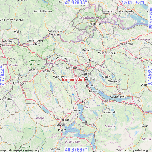
Birmensdorf GPS coordinates[2]
47° 21' 18.54" North, 8° 26' 33.216" East
| Map corner | latitude | longitude |
|---|---|---|
| Upper-left | 47.82933°, | 7.73944° |
| Center: | 47.35515°, | 8.44256° |
| Lower-right: | 46.87667°, | 9.14569° |
| Map W x H: | 105.9×105.9 km | = 65.8×65.8mi |
| max Lat: | 47.76737° ⇑34.8% North |
| Birmensdorf: | 47.35515° |
| min Lat: | ⇓65.2% South 45.83203° |
| min Long | Birmensdorf | max Long |
| 5.97153° | 8.44256° | 10.44624° |
| W 52.6%⇐ | ⇒47.4% E |
Elevation
Elevation of Birmensdorf is 472 m = 1549 ft, and this is 86.2 m = 283 ft below average elevation for this country.
| Max E: |
1845 m = 6053 ft | 52.7% |
| Avg. | 558.2 m = 1831 ft | |
| Birmensdorf | 472 m = 1549 ft | |
Min E: |
197 m = 646 ft | 47.3% |
See also: Switzerland elevation on elevation.city.
Geographical zone
Birmensdorf is located in North temperate zone (between Tropic of Cancer and the Arctic Circle). Distance of this North polar circle is 2135.8 km =1327.1 mi to North.| Distance of | km | miles | from Birmensdorf |
|---|---|---|---|
| North Pole | 4741.7 | 2946.4 | to North |
| Arctic Circle | 2135.8 | 1327.1 | to North |
| Tropic Cancer | 2659.5 | 1652.5 | to South |
| Equator | 5265.4 | 3271.8 | to South |


Nearby cities:
15 places around Birmensdorf: (largest is in red/bold)
• Aesch
2.1 km =1.3 mi,  183°
183°
• Birmensdorf / Haslen
1.5 km =0.9 mi,  68°
68°
• Sellenbüren
3.3 km =2.1 mi,  112°
112°
• Uitikon
1.9 km =1.2 mi,  34°
34°
• Uitikon / Halde
2.2 km =1.4 mi, 27°
• Uitikon / Uitikon (Dorfkern)
1.9 km =1.2 mi,  24°
24°
• Uitikon / Waldegg
1.9 km =1.2 mi,  61°
61°
• Urdorf
3.6 km =2.2 mi,  339°
339°
• Urdorf / Baumgarten
3.1 km =1.9 mi,  328°
328°
• Urdorf / Fadmatt
3.2 km =2 mi, 340°
• Urdorf / Heidenkeller
3.5 km =2.2 mi, 341°
• Urdorf / Ob der Bahn
3.6 km =2.2 mi,  348°
348°
• Urdorf / Oberurdorf
3.2 km =2 mi, 333°
• Wettswil
3.2 km =2 mi,  128°
128°
• Wettswil / Wettswil (Dorf)
2.7 km =1.7 mi,  124°
124°
Sources, notices
• [Note1] Compared only with cities in Switzerland existing in our database
• [Src1] Map data: © OpenStreetMap contributors (CC-BY-SA)
• [Src2] Other city data from geonames.org with taken over terms of usage.
• [Src3] Geographical zone / Annual Mean Temperature by Robert A. Rohde @ Wikipedia
