Uitikon / Uitikon (Dorfkern) geodata
Uitikon / Uitikon (Dorfkern) (Zurich) is a section of populated place; located in Switzerland in Europe/Zurich (GMT+2) time zone. With population of 640 people, there are 1657 cities with bigger population in this country. Compared to other cities in Switzerland, 67.7% of cities are located further ↓South; 53.4% of cities are located further ←West and 66.7% of cities have lower elevation than Uitikon / Uitikon (Dorfkern). Note1
Current local time in Uitikon / Uitikon (Dorfkern):
08:58 AM, SaturdayDifference from your time zone: hours


Uitikon / Uitikon (Dorfkern) GPS coordinates[2]
47° 22' 14.304" North, 8° 27' 11.556" East
| Map corner | latitude | longitude |
|---|---|---|
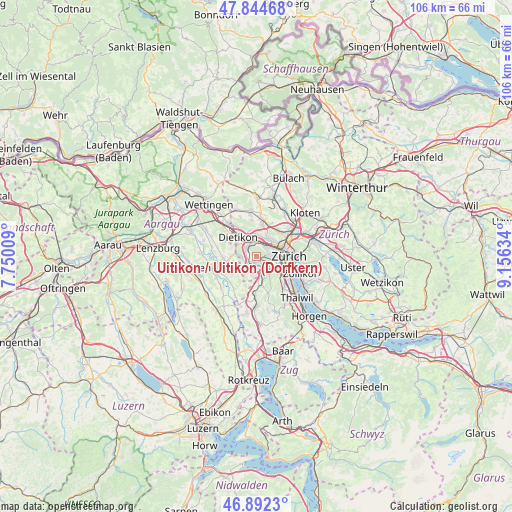
| Upper-left | 47.84468°, | 7.75009° |
| Center: | 47.37064°, | 8.45321° |
| Lower-right: | 46.8923°, | 9.15634° |
| Map W x H: | 105.9×105.9 km | = 65.8×65.8mi |
| max Lat: | 47.76737° ⇑32.3% North |
| Uitikon / Uitikon (Dorfkern): | 47.37064° |
| min Lat: | ⇓67.7% South 45.83203° |
| min Long | Uitikon / Uitik | max Long |
| 5.97153° | 8.45321° | 10.44624° |
| W 53.4%⇐ | ⇒46.6% E |
Elevation
Elevation of Uitikon / Uitikon (Dorfkern) is 555 m = 1821 ft, and this is 3.2 m = 10 ft below average elevation for this country.
| Max E: |
1845 m = 6053 ft | 33.3% |
| Avg. | 558.2 m = 1831 ft | |
| Uitikon / Uitikon (Dorfkern) | 555 m = 1821 ft | |
Min E: |
197 m = 646 ft | 66.7% |
See also: Switzerland elevation on elevation.city.
Geographical zone
Uitikon / Uitikon (Dorfkern) is located in North temperate zone (between Tropic of Cancer and the Arctic Circle). Distance of this North polar circle is 2134.1 km =1326.1 mi to North.| Distance of | km | miles | from Uitikon / Uitikon (Dorfkern) |
|---|---|---|---|
| North Pole | 4739.9 | 2945.2 | to North |
| Arctic Circle | 2134.1 | 1326.1 | to North |
| Tropic Cancer | 2661.2 | 1653.6 | to South |
| Equator | 5267.1 | 3272.8 | to South |


Nearby cities:
15 places around Uitikon / Uitikon (Dorfkern): (largest is in red/bold)
• Birmensdorf
1.9 km =1.2 mi,  204°
204°
• Birmensdorf / Haslen
1.3 km =0.8 mi,  155°
155°
• Schlieren / Kamp
2.6 km =1.6 mi,  345°
345°
• Uitikon
0.3 km =0.2 mi,  120°
120°
• Uitikon / Halde
0.3 km =0.2 mi,  45°
45°
• Uitikon / Waldegg
1.2 km =0.7 mi,  133°
133°
• Urdorf
2.6 km =1.6 mi,  307°
307°
• Urdorf / Baumgarten
2.6 km =1.6 mi,  291°
291°
• Urdorf / Fadmatt
2.3 km =1.4 mi,  304°
304°
• Urdorf / Heidenkeller
2.5 km =1.6 mi, 309°
• Urdorf / Ob der Bahn
2.4 km =1.5 mi,  320°
320°
• Urdorf / Oberurdorf
2.5 km =1.6 mi, 296°
• Urdorf / Zentrum
2.8 km =1.7 mi, 307°
• Zürich (Kreis 9)
2.4 km =1.5 mi,  56°
56°
• Zürich (Kreis 9) / Albisrieden
2.8 km =1.7 mi,  82°
82°
Sources, notices
• [Note1] Compared only with cities in Switzerland existing in our database
• [Src1] Map data: © OpenStreetMap contributors (CC-BY-SA)
• [Src2] Other city data from geonames.org with taken over terms of usage.
• [Src3] Geographical zone / Annual Mean Temperature by Robert A. Rohde @ Wikipedia
