Dabakala geodata
Dabakala (Vallée du Bandama) is a seat of a third-order administrative division; located in Ivory Coast in Africa/Abidjan (GMT+0) time zone. With population of 13,717 people, there are 57 cities with bigger population in this country. Compared to other cities in Ivory Coast, 79.5% of cities are located further ↓South; 66.7% of cities are located further ←West and 59% of cities have lower elevation than Dabakala. Note1


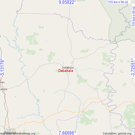
Dabakala GPS coordinates[2]
8° 21' 47.556" North, 4° 25' 43.068" West
| Map corner | latitude | longitude |
|---|---|---|
| Upper-left | 9.05822°, | -5.13176° |
| Center: | 8.36321°, | -4.42863° |
| Lower-right: | 7.66696°, | -3.72551° |
| Map W x H: | 154.7×154.7 km | = 96.1×96.1mi |
| max Lat: | 10.48115° ⇑20.5% North |
| Dabakala: | 8.36321° |
| min Lat: | ⇓79.5% South 4.42295° |
| min Long | Dabakala | max Long |
| -8.42592° | -4.42863° | -2.80003° |
| W 66.7%⇐ | ⇒33.3% E |
Elevation
Elevation of Dabakala is 254 m = 833 ft, and this is 29.7 m = 97 ft above average elevation for this country.
| Max E: |
556 m = 1824 ft | 41% |
| Dabakala | 254 m 833 ft | |
| Avg. | 224.3 m = 736 ft | |
Min E: |
7 m = 23 ft | 59% |
See also: Ivory Coast elevation on elevation.city.
Geographical zone
Dabakala is located in North Torrid zone (between Equator and Tropic of Cancer). Distance of Equator is 929.9 km =577.8 mi to South.| Distance of | km | miles | from Dabakala |
|---|---|---|---|
| North Pole | 9077.2 | 5640.3 | to North |
| Arctic Circle | 6471.3 | 4021.1 | to North |
| Tropic Cancer | 1676 | 1041.4 | to North |
| Equator | 929.9 | 577.8 | to South |


Nearby cities:
15 places around Dabakala: (largest is in red/bold)
• Bocanda
144.8 km =90 mi,  183°
183°
• Botro
112.5 km =69.9 mi,  239°
239°
• Bouaké
99.6 km =61.9 mi,  221°
221°
• Béoumi
148.2 km =92.1 mi, 238°
• Didiévi
146.7 km =91.2 mi,  200°
200°
• Katiola
78.1 km =48.5 mi,  251°
251°
• Kong
89.7 km =55.7 mi,  347°
347°
• Kouassi-Kouassikro
116.9 km =72.6 mi,  193°
193°
• M’Bahiakro
101.2 km =62.9 mi,  174°
174°
• Nassian
105.7 km =65.7 mi,  84°
84°
• Niakaramandougou
100.3 km =62.3 mi,  289°
289°
• Prikro
92.8 km =57.7 mi,  149°
149°
• Sakassou
138.8 km =86.2 mi, 223°
• Sandégué
103.9 km =64.6 mi,  115°
115°
• Tanda
152.1 km =94.5 mi,  114°
114°
Sources, notices
• [Note1] Compared only with cities in Ivory Coast existing in our database
• [Src1] Map data: © OpenStreetMap contributors (CC-BY-SA)
• [Src2] Other city data from geonames.org with taken over terms of usage.
• [Src3] Geographical zone / Annual Mean Temperature by Robert A. Rohde @ Wikipedia
