Taabo geodata
Taabo (Lagunes) is a seat of a third-order administrative division; located in Ivory Coast in Africa/Abidjan (GMT+0) time zone. In our database, there are 63 cities with bigger population. Compared to other cities in Ivory Coast, 70.1% of cities are located further ↑North; 56.4% of cities are located further ←West and 71.8% of cities have higher elevation than Taabo. Note1


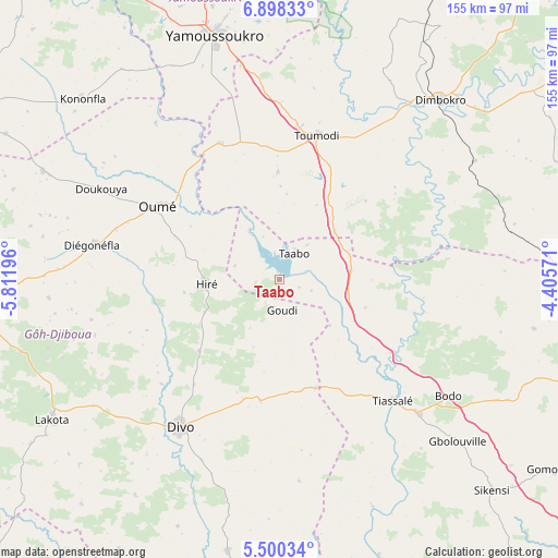
Taabo GPS coordinates[2]
6° 11' 59.28" North, 5° 6' 31.824" West
| Map corner | latitude | longitude |
|---|---|---|
| Upper-left | 6.89833°, | -5.81196° |
| Center: | 6.1998°, | -5.10884° |
| Lower-right: | 5.50034°, | -4.40571° |
| Map W x H: | 155.4×155.4 km | = 96.6×96.6mi |
| max Lat: | 10.48115° ⇑70.1% North |
| Taabo: | 6.1998° |
| min Lat: | ⇓29.9% South 4.42295° |
| min Long | Taabo | max Long |
| -8.42592° | -5.10884° | -2.80003° |
| W 56.4%⇐ | ⇒43.6% E |
Elevation
Elevation of Taabo is 139 m = 456 ft, and this is 85.3 m = 280 ft below average elevation for this country.
| Max E: |
556 m = 1824 ft | 71.8% |
| Avg. | 224.3 m = 736 ft | |
| Taabo | 139 m = 456 ft | |
Min E: |
7 m = 23 ft | 28.2% |
See also: Ivory Coast elevation on elevation.city.
Geographical zone
Taabo is located in North Torrid zone (between Equator and Tropic of Cancer). Distance of Equator is 689.4 km =428.4 mi to South.| Distance of | km | miles | from Taabo |
|---|---|---|---|
| North Pole | 9317.7 | 5789.7 | to North |
| Arctic Circle | 6711.8 | 4170.5 | to North |
| Tropic Cancer | 1916.6 | 1190.9 | to North |
| Equator | 689.4 | 428.4 | to South |


Nearby cities:
15 places around Taabo: (largest is in red/bold)
• Agboville
103.5 km =64.3 mi,  106°
106°
• Attiégouakro
63.8 km =39.6 mi,  359°
359°
• Dimbokro
66.8 km =41.5 mi,  41°
41°
• Divo
48.8 km =30.3 mi,  214°
214°
• Djékanou
31.6 km =19.6 mi, 358°
• Gagnoa
93.4 km =58 mi,  265°
265°
• Guitry
77 km =47.8 mi,  190°
190°
• Lakota
74.5 km =46.3 mi,  238°
238°
• M’Batto
88.3 km =54.9 mi,  69°
69°
• Oumé
39.7 km =24.7 mi,  300°
300°
• Sikensi
83.6 km =51.9 mi,  134°
134°
• Sinfra
100.3 km =62.3 mi, 297°
• Tiassalé
46.1 km =28.6 mi,  136°
136°
• Toumodi
41.1 km =25.5 mi,  14°
14°
• Yamoussoukro
71.5 km =44.4 mi,  344°
344°
Sources, notices
• [Note1] Compared only with cities in Ivory Coast existing in our database
• [Src1] Map data: © OpenStreetMap contributors (CC-BY-SA)
• [Src2] Other city data from geonames.org with taken over terms of usage.
• [Src3] Geographical zone / Annual Mean Temperature by Robert A. Rohde @ Wikipedia
