Sinfra geodata
Sinfra (Zanzan) is a populated place; located in Ivory Coast in Africa/Abidjan (GMT+0) time zone. With population of 59,919 people, there are 19 cities with bigger population in this country. Compared to other cities in Ivory Coast, 58.1% of cities are located further ↑North; 62.4% of cities are located further →East and 64.1% of cities have lower elevation than Sinfra. Note1


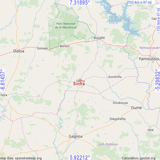
Sinfra GPS coordinates[2]
6° 37' 15.708" North, 5° 54' 41.184" West
| Map corner | latitude | longitude |
|---|---|---|
| Upper-left | 7.31895°, | -6.61457° |
| Center: | 6.62103°, | -5.91144° |
| Lower-right: | 5.92212°, | -5.20832° |
| Map W x H: | 155.3×155.3 km | = 96.5×96.5mi |
| max Lat: | 10.48115° ⇑58.1% North |
| Sinfra: | 6.62103° |
| min Lat: | ⇓41.9% South 4.42295° |
| min Long | Sinfra | max Long |
| -8.42592° | -5.91144° | -2.80003° |
| W 37.6%⇐ | ⇒62.4% E |
Elevation
Elevation of Sinfra is 265 m = 869 ft, and this is 40.7 m = 134 ft above average elevation for this country.
| Max E: |
556 m = 1824 ft | 35.9% |
| Sinfra | 265 m 869 ft | |
| Avg. | 224.3 m = 736 ft | |
Min E: |
7 m = 23 ft | 64.1% |
See also: Sinfra elevation on elevation.city.
Geographical zone
Sinfra is located in North Torrid zone (between Equator and Tropic of Cancer). Distance of Equator is 736.2 km =457.5 mi to South.| Distance of | km | miles | from Sinfra |
|---|---|---|---|
| North Pole | 9270.9 | 5760.7 | to North |
| Arctic Circle | 6665 | 4141.4 | to North |
| Tropic Cancer | 1869.7 | 1161.8 | to North |
| Equator | 736.2 | 457.5 | to South |


Nearby cities:
15 places around Sinfra: (largest is in red/bold)
• Attiégouakro
89.7 km =55.7 mi,  79°
79°
• Bouaflé
45 km =28 mi,  24°
24°
• Daloa
66 km =41 mi,  295°
295°
• Djékanou
89.2 km =55.4 mi,  99°
99°
• Gagnoa
54.6 km =33.9 mi,  184°
184°
• Guibéroua
51.3 km =31.9 mi,  214°
214°
• Guéyo
105.2 km =65.4 mi,  189°
189°
• Issia
75.8 km =47.1 mi,  259°
259°
• Lakota
89.7 km =55.7 mi,  163°
163°
• Oumé
60.6 km =37.7 mi,  115°
115°
• Taabo
100.3 km =62.3 mi, 117°
• Tiébissou
96.5 km =60 mi,  51°
51°
• Toumodi
99 km =61.5 mi,  94°
94°
• Yamoussoukro
73.5 km =45.7 mi,  72°
72°
• Zuénoula
91.3 km =56.7 mi,  350°
350°
Sources, notices
• [Note1] Compared only with cities in Ivory Coast existing in our database
• [Src1] Map data: © OpenStreetMap contributors (CC-BY-SA)
• [Src2] Other city data from geonames.org with taken over terms of usage.
• [Src3] Geographical zone / Annual Mean Temperature by Robert A. Rohde @ Wikipedia
