Agboville geodata
Agboville (Lagunes) is a seat of a second-order administrative division; located in Ivory Coast in Africa/Abidjan (GMT+0) time zone. With population of 81,770 people, there are 12 cities with bigger population in this country. Compared to other cities in Ivory Coast, 75.2% of cities are located further ↑North; 71.8% of cities are located further ←West and 89.7% of cities have higher elevation than Agboville. Note1


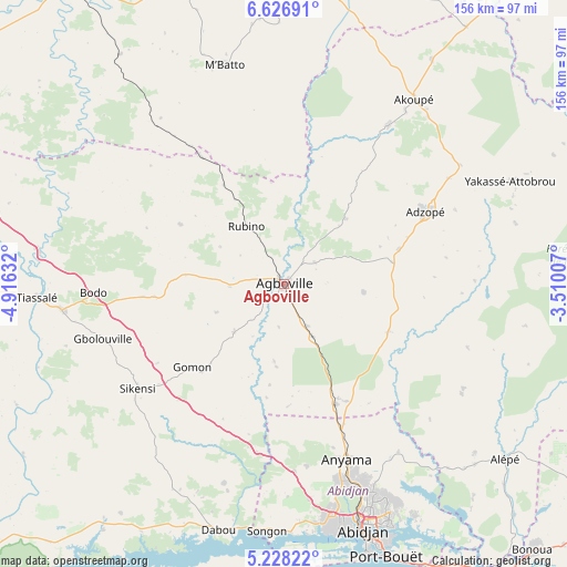
Agboville GPS coordinates[2]
5° 55' 40.836" North, 4° 12' 47.484" West
| Map corner | latitude | longitude |
|---|---|---|
| Upper-left | 6.62691°, | -4.91632° |
| Center: | 5.92801°, | -4.21319° |
| Lower-right: | 5.22822°, | -3.51007° |
| Map W x H: | 155.5×155.5 km | = 96.6×96.6mi |
| max Lat: | 10.48115° ⇑75.2% North |
| Agboville: | 5.92801° |
| min Lat: | ⇓24.8% South 4.42295° |
| min Long | Agboville | max Long |
| -8.42592° | -4.21319° | -2.80003° |
| W 71.8%⇐ | ⇒28.2% E |
Elevation
Elevation of Agboville is 35 m = 115 ft, and this is 189.3 m = 621 ft below average elevation for this country.
| Max E: |
556 m = 1824 ft | 89.7% |
| Avg. | 224.3 m = 736 ft | |
| Agboville | 35 m = 115 ft | |
Min E: |
7 m = 23 ft | 10.3% |
See also: Agboville elevation on elevation.city.
Geographical zone
Agboville is located in North Torrid zone (between Equator and Tropic of Cancer). Distance of Equator is 659.1 km =409.5 mi to South.| Distance of | km | miles | from Agboville |
|---|---|---|---|
| North Pole | 9347.9 | 5808.5 | to North |
| Arctic Circle | 6742 | 4189.3 | to North |
| Tropic Cancer | 1946.8 | 1209.7 | to North |
| Equator | 659.1 | 409.5 | to South |


Nearby cities:
15 places around Agboville: (largest is in red/bold)
• Abidjan
72.2 km =44.9 mi,  162°
162°
• Abobo
61 km =37.9 mi, 159°
• Adzopé
43.6 km =27.1 mi,  62°
62°
• Affery
52.3 km =32.5 mi,  33°
33°
• Agou
30.4 km =18.9 mi,  78°
78°
• Akoupé
62.2 km =38.6 mi,  35°
35°
• Anyama
51.4 km =31.9 mi, 159°
• Azaguié
36.2 km =22.5 mi, 156°
• Bingerville
73.2 km =45.5 mi,  150°
150°
• Dabou
69.4 km =43.1 mi,  195°
195°
• M’Batto
62.6 km =38.9 mi,  345°
345°
• Sikensi
49.2 km =30.6 mi,  234°
234°
• Songon
67.8 km =42.1 mi,  183°
183°
• Tiassalé
67.5 km =41.9 mi,  267°
267°
• Yakassé-Attobrou
68.3 km =42.4 mi,  65°
65°
Sources, notices
• [Note1] Compared only with cities in Ivory Coast existing in our database
• [Src1] Map data: © OpenStreetMap contributors (CC-BY-SA)
• [Src2] Other city data from geonames.org with taken over terms of usage.
• [Src3] Geographical zone / Annual Mean Temperature by Robert A. Rohde @ Wikipedia
