Divo geodata
Divo (Gôh-Djiboua) is a seat of a second-order administrative division; located in Ivory Coast in Africa/Abidjan (GMT+0) time zone. With population of 127,867 people, there are 8 cities with bigger population in this country. Compared to other cities in Ivory Coast, 78.6% of cities are located further ↑North; 53% of cities are located further →East and 67.5% of cities have higher elevation than Divo. Note1


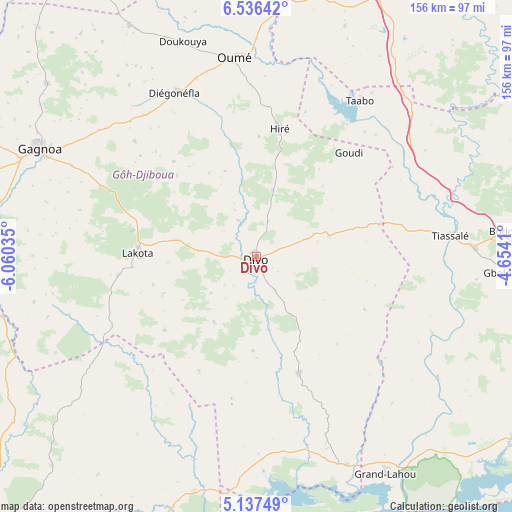
Divo GPS coordinates[2]
5° 50' 14.604" North, 5° 21' 26.028" West
| Map corner | latitude | longitude |
|---|---|---|
| Upper-left | 6.53642°, | -6.06035° |
| Center: | 5.83739°, | -5.35723° |
| Lower-right: | 5.13749°, | -4.6541° |
| Map W x H: | 155.5×155.5 km | = 96.6×96.6mi |
| max Lat: | 10.48115° ⇑78.6% North |
| Divo: | 5.83739° |
| min Lat: | ⇓21.4% South 4.42295° |
| min Long | Divo | max Long |
| -8.42592° | -5.35723° | -2.80003° |
| W 47%⇐ | ⇒53% E |
Elevation
Elevation of Divo is 147 m = 482 ft, and this is 77.3 m = 254 ft below average elevation for this country.
| Max E: |
556 m = 1824 ft | 67.5% |
| Avg. | 224.3 m = 736 ft | |
| Divo | 147 m = 482 ft | |
Min E: |
7 m = 23 ft | 32.5% |
See also: Divo elevation on elevation.city.
Geographical zone
Divo is located in North Torrid zone (between Equator and Tropic of Cancer). Distance of Equator is 649.1 km =403.3 mi to South.| Distance of | km | miles | from Divo |
|---|---|---|---|
| North Pole | 9358 | 5814.8 | to North |
| Arctic Circle | 6752.1 | 4195.6 | to North |
| Tropic Cancer | 1956.9 | 1216 | to North |
| Equator | 649.1 | 403.3 | to South |


Nearby cities:
15 places around Divo: (largest is in red/bold)
• Attiégouakro
107.6 km =66.9 mi,  14°
14°
• Djékanou
76.7 km =47.7 mi,  20°
20°
• Fresco
87.2 km =54.2 mi,  195°
195°
• Gagnoa
73.3 km =45.5 mi,  296°
296°
• Grand-Lahou
76.1 km =47.3 mi,  149°
149°
• Guibéroua
100.5 km =62.4 mi, 296°
• Guitry
37.6 km =23.4 mi,  159°
159°
• Guéyo
80.7 km =50.1 mi,  258°
258°
• Lakota
35.9 km =22.3 mi,  271°
271°
• Oumé
61 km =37.9 mi,  353°
353°
• Sikensi
88.7 km =55.1 mi,  102°
102°
• Sinfra
106.5 km =66.2 mi,  324°
324°
• Taabo
48.8 km =30.3 mi,  34°
34°
• Tiassalé
59.5 km =37 mi,  83°
83°
• Toumodi
88.5 km =55 mi, 25°
Sources, notices
• [Note1] Compared only with cities in Ivory Coast existing in our database
• [Src1] Map data: © OpenStreetMap contributors (CC-BY-SA)
• [Src2] Other city data from geonames.org with taken over terms of usage.
• [Src3] Geographical zone / Annual Mean Temperature by Robert A. Rohde @ Wikipedia
