Gagnoa geodata
Gagnoa (Gôh-Djiboua) is a seat of a first-order administrative division; located in Ivory Coast in Africa/Abidjan (GMT+0) time zone. With population of 123,184 people, there are 9 cities with bigger population in this country. Compared to other cities in Ivory Coast, 71.8% of cities are located further ↑North; 63.2% of cities are located further →East and 57.3% of cities have higher elevation than Gagnoa. Note1


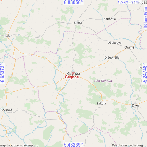
Gagnoa GPS coordinates[2]
6° 7' 54.948" North, 5° 57' 2.16" West
| Map corner | latitude | longitude |
|---|---|---|
| Upper-left | 6.83056°, | -6.65373° |
| Center: | 6.13193°, | -5.9506° |
| Lower-right: | 5.43239°, | -5.24748° |
| Map W x H: | 155.5×155.5 km | = 96.6×96.6mi |
| max Lat: | 10.48115° ⇑71.8% North |
| Gagnoa: | 6.13193° |
| min Lat: | ⇓28.2% South 4.42295° |
| min Long | Gagnoa | max Long |
| -8.42592° | -5.9506° | -2.80003° |
| W 36.8%⇐ | ⇒63.2% E |
Elevation
Elevation of Gagnoa is 202 m = 663 ft, and this is 22.3 m = 73 ft below average elevation for this country.
| Max E: |
556 m = 1824 ft | 57.3% |
| Avg. | 224.3 m = 736 ft | |
| Gagnoa | 202 m = 663 ft | |
Min E: |
7 m = 23 ft | 42.7% |
See also: Gagnoa elevation on elevation.city.
Geographical zone
Gagnoa is located in North Torrid zone (between Equator and Tropic of Cancer). Distance of Equator is 681.8 km =423.7 mi to South.| Distance of | km | miles | from Gagnoa |
|---|---|---|---|
| North Pole | 9325.3 | 5794.5 | to North |
| Arctic Circle | 6719.4 | 4175.2 | to North |
| Tropic Cancer | 1924.1 | 1195.6 | to North |
| Equator | 681.8 | 423.7 | to South |


Nearby cities:
15 places around Gagnoa: (largest is in red/bold)
• Bouaflé
98.1 km =61 mi,  13°
13°
• Daloa
99.6 km =61.9 mi,  326°
326°
• Divo
73.3 km =45.5 mi,  116°
116°
• Djékanou
100.2 km =62.3 mi,  67°
67°
• Guibéroua
27.1 km =16.8 mi,  295°
295°
• Guitry
104 km =64.6 mi,  130°
130°
• Guéyo
51.1 km =31.8 mi,  195°
195°
• Issia
80.8 km =50.2 mi, 299°
• Lakota
43.4 km =27 mi,  136°
136°
• Oumé
65.2 km =40.5 mi,  64°
64°
• Sinfra
54.6 km =33.9 mi,  4°
4°
• Soubré
81 km =50.3 mi,  241°
241°
• Taabo
93.4 km =58 mi,  85°
85°
• Toumodi
113.5 km =70.5 mi, 65°
• Yamoussoukro
106.8 km =66.4 mi,  44°
44°
Sources, notices
• [Note1] Compared only with cities in Ivory Coast existing in our database
• [Src1] Map data: © OpenStreetMap contributors (CC-BY-SA)
• [Src2] Other city data from geonames.org with taken over terms of usage.
• [Src3] Geographical zone / Annual Mean Temperature by Robert A. Rohde @ Wikipedia
