Oumé geodata
Oumé (Gôh-Djiboua) is a seat of a third-order administrative division; located in Ivory Coast in Africa/Abidjan (GMT+0) time zone. With population of 52,070 people, there are 23 cities with bigger population in this country. Compared to other cities in Ivory Coast, 66.7% of cities are located further ↑North; 54.7% of cities are located further →East and 54.7% of cities have higher elevation than Oumé. Note1


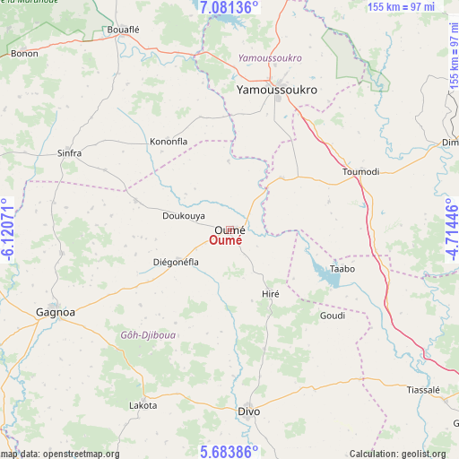
Oumé GPS coordinates[2]
6° 22' 59.124" North, 5° 25' 3.324" West
| Map corner | latitude | longitude |
|---|---|---|
| Upper-left | 7.08136°, | -6.12071° |
| Center: | 6.38309°, | -5.41759° |
| Lower-right: | 5.68386°, | -4.71446° |
| Map W x H: | 155.4×155.4 km | = 96.6×96.6mi |
| max Lat: | 10.48115° ⇑66.7% North |
| Oumé: | 6.38309° |
| min Lat: | ⇓33.3% South 4.42295° |
| min Long | Oumé | max Long |
| -8.42592° | -5.41759° | -2.80003° |
| W 45.3%⇐ | ⇒54.7% E |
Elevation
Elevation of Oumé is 211 m = 692 ft, and this is 13.3 m = 44 ft below average elevation for this country.
| Max E: |
556 m = 1824 ft | 54.7% |
| Avg. | 224.3 m = 736 ft | |
| Oumé | 211 m = 692 ft | |
Min E: |
7 m = 23 ft | 45.3% |
See also: Oumé elevation on elevation.city.
Geographical zone
Oumé is located in North Torrid zone (between Equator and Tropic of Cancer). Distance of Equator is 709.7 km =441 mi to South.| Distance of | km | miles | from Oumé |
|---|---|---|---|
| North Pole | 9297.3 | 5777.1 | to North |
| Arctic Circle | 6691.4 | 4157.8 | to North |
| Tropic Cancer | 1896.2 | 1178.2 | to North |
| Equator | 709.7 | 441 | to South |


Nearby cities:
15 places around Oumé: (largest is in red/bold)
• Attiégouakro
54.9 km =34.1 mi,  37°
37°
• Bouaflé
76.6 km =47.6 mi,  331°
331°
• Dimbokro
84 km =52.2 mi,  69°
69°
• Divo
61 km =37.9 mi,  173°
173°
• Djékanou
35.2 km =21.9 mi, 71°
• Gagnoa
65.2 km =40.5 mi,  244°
244°
• Guibéroua
84.8 km =52.7 mi,  259°
259°
• Guitry
98 km =60.9 mi, 168°
• Lakota
66.3 km =41.2 mi,  206°
206°
• Sinfra
60.6 km =37.7 mi,  295°
295°
• Taabo
39.7 km =24.7 mi,  120°
120°
• Tiassalé
85 km =52.8 mi,  129°
129°
• Tiébissou
88.7 km =55.1 mi,  13°
13°
• Toumodi
48.3 km =30 mi, 66°
• Yamoussoukro
51.1 km =31.8 mi,  17°
17°
Sources, notices
• [Note1] Compared only with cities in Ivory Coast existing in our database
• [Src1] Map data: © OpenStreetMap contributors (CC-BY-SA)
• [Src2] Other city data from geonames.org with taken over terms of usage.
• [Src3] Geographical zone / Annual Mean Temperature by Robert A. Rohde @ Wikipedia
