Lakota geodata
Lakota (Gôh-Djiboua) is a seat of a third-order administrative division; located in Ivory Coast in Africa/Abidjan (GMT+0) time zone. With population of 38,055 people, there are 35 cities with bigger population in this country. Compared to other cities in Ivory Coast, 77.8% of cities are located further ↑North; 58.1% of cities are located further →East and 52.1% of cities have lower elevation than Lakota. Note1


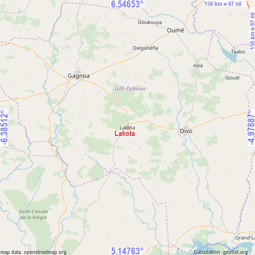
Lakota GPS coordinates[2]
5° 50' 51.072" North, 5° 40' 55.2" West
| Map corner | latitude | longitude |
|---|---|---|
| Upper-left | 6.54653°, | -6.38512° |
| Center: | 5.84752°, | -5.682° |
| Lower-right: | 5.14763°, | -4.97887° |
| Map W x H: | 155.5×155.5 km | = 96.6×96.6mi |
| max Lat: | 10.48115° ⇑77.8% North |
| Lakota: | 5.84752° |
| min Lat: | ⇓22.2% South 4.42295° |
| min Long | Lakota | max Long |
| -8.42592° | -5.682° | -2.80003° |
| W 41.9%⇐ | ⇒58.1% E |
Elevation
Elevation of Lakota is 228 m = 748 ft, and this is 3.7 m = 12 ft above average elevation for this country.
| Max E: |
556 m = 1824 ft | 47.9% |
| Lakota | 228 m 748 ft | |
| Avg. | 224.3 m = 736 ft | |
Min E: |
7 m = 23 ft | 52.1% |
See also: Ivory Coast elevation on elevation.city.
Geographical zone
Lakota is located in North Torrid zone (between Equator and Tropic of Cancer). Distance of Equator is 650.2 km =404 mi to South.| Distance of | km | miles | from Lakota |
|---|---|---|---|
| North Pole | 9356.9 | 5814.1 | to North |
| Arctic Circle | 6751 | 4194.9 | to North |
| Tropic Cancer | 1955.7 | 1215.2 | to North |
| Equator | 650.2 | 404 | to South |


Nearby cities:
15 places around Lakota: (largest is in red/bold)
• Divo
35.9 km =22.3 mi,  91°
91°
• Djékanou
94.5 km =58.7 mi,  41°
41°
• Fresco
86 km =53.4 mi,  171°
171°
• Gagnoa
43.4 km =27 mi,  316°
316°
• Grand-Lahou
100.2 km =62.3 mi,  131°
131°
• Guibéroua
69.4 km =43.1 mi,  308°
308°
• Guitry
61 km =37.9 mi, 126°
• Guéyo
46.6 km =29 mi,  247°
247°
• Oumé
66.3 km =41.2 mi,  26°
26°
• Sassandra
108.9 km =67.7 mi,  204°
204°
• Sinfra
89.7 km =55.7 mi,  343°
343°
• Soubré
101.1 km =62.8 mi,  265°
265°
• Taabo
74.5 km =46.3 mi,  58°
58°
• Tiassalé
95.2 km =59.2 mi, 86°
• Toumodi
107.9 km =67 mi, 42°
Sources, notices
• [Note1] Compared only with cities in Ivory Coast existing in our database
• [Src1] Map data: © OpenStreetMap contributors (CC-BY-SA)
• [Src2] Other city data from geonames.org with taken over terms of usage.
• [Src3] Geographical zone / Annual Mean Temperature by Robert A. Rohde @ Wikipedia
