Lautaro geodata
Lautaro (Araucanía) is a populated place; located in Chile in America/Santiago (GMT-4) time zone. With population of 21,579 people, there are 79 cities with bigger population in this country. Compared to other cities in Chile, 69% of cities are located further ↑North; 65.5% of cities are located further →East and 64.1% of cities have lower elevation than Lautaro. Note1


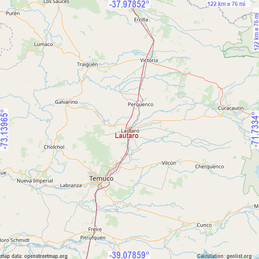
Lautaro GPS coordinates[2]
38° 31' 50.376" South, 72° 26' 11.472" West
| Map corner | latitude | longitude |
|---|---|---|
| Upper-left | -37.97852°, | -73.13965° |
| Center: | -38.53066°, | -72.43652° |
| Lower-right: | -39.07859°, | -71.7334° |
| Map W x H: | 122.3×122.3 km | = 76×76mi |
| max Lat: | -18.19821° ⇑69% North |
| Lautaro: | -38.53066° |
| min Lat: | ⇓31% South -54.93355° |
| min Long | Lautaro | max Long |
| -109.42438° | -72.43652° | -67.60963° |
| W 34.5%⇐ | ⇒65.5% E |
Elevation
Elevation of Lautaro is 217 m = 712 ft, and this is 56 m = 184 ft below average elevation for this country.
| Max E: |
3544 m = 11627 ft | 35.9% |
| Avg. | 273 m = 896 ft | |
| Lautaro | 217 m = 712 ft | |
Min E: |
1 m = 3 ft | 64.1% |
See also: Chile elevation on elevation.city.
Geographical zone
Lautaro is located in South temperate zone (between Tropic of Capricorn and the Antarctic Circle). Distance of this Southern Tropic circle is 1678.3 km =1042.8 mi to North.| Distance of | km | miles | from Lautaro |
|---|---|---|---|
| Equator | 4284.2 | 2662.1 | to North |
| Tropic Capricorn | 1678.3 | 1042.8 | to North |
| Antarctic Circle | 3117 | 1936.8 | to South |
| South Pole | 5722.9 | 3556 | to South |


Nearby cities:
15 places around Lautaro: (largest is in red/bold)
• Angol
85.4 km =53.1 mi,  343°
343°
• Carahue
66.1 km =41.1 mi,  252°
252°
• Collipulli
64.1 km =39.8 mi,  0°
0°
• Freire
49.7 km =30.9 mi,  199°
199°
• Loncoche
94.5 km =58.7 mi,  190°
190°
• Mulchén
91.9 km =57.1 mi,  10°
10°
• Nacimiento
116.2 km =72.2 mi,  349°
349°
• Nueva Imperial
50.6 km =31.4 mi,  241°
241°
• Pitrufquén
53.6 km =33.3 mi, 198°
• Pucón
93.4 km =58 mi,  153°
153°
• Temuco
27.2 km =16.9 mi,  211°
211°
• Traiguén
37.3 km =23.2 mi,  326°
326°
• Victoria
34.3 km =21.3 mi,  15°
15°
• Vilcún
23.9 km =14.9 mi,  129°
129°
• Villarrica
85.9 km =53.4 mi,  167°
167°
Sources, notices
• [Note1] Compared only with cities in Chile existing in our database
• [Src1] Map data: © OpenStreetMap contributors (CC-BY-SA)
• [Src2] Other city data from geonames.org with taken over terms of usage.
• [Src3] Geographical zone / Annual Mean Temperature by Robert A. Rohde @ Wikipedia
