Chillán geodata
Chillán (Ñuble) is a seat of a first-order administrative division; located in Chile in America/Santiago (GMT-4) time zone. With population of 150,396 people, there are 17 cities with bigger population in this country. Compared to other cities in Chile, 52.4% of cities are located further ↑North; 56.6% of cities are located further →East and 51% of cities have higher elevation than Chillán. Note1


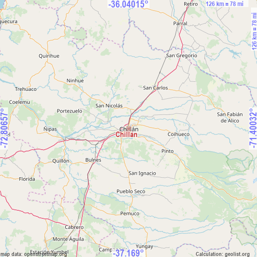
Chillán GPS coordinates[2]
36° 36' 23.904" South, 72° 6' 12.384" West
| Map corner | latitude | longitude |
|---|---|---|
| Upper-left | -36.04015°, | -72.80657° |
| Center: | -36.60664°, | -72.10344° |
| Lower-right: | -37.169°, | -71.40032° |
| Map W x H: | 125.5×125.5 km | = 78×78mi |
| max Lat: | -18.19821° ⇑52.4% North |
| Chillán: | -36.60664° |
| min Lat: | ⇓47.6% South -54.93355° |
| min Long | Chillán | max Long |
| -109.42438° | -72.10344° | -67.60963° |
| W 43.4%⇐ | ⇒56.6% E |
Elevation
Elevation of Chillán is 132 m = 433 ft, and this is 141 m = 463 ft below average elevation for this country.
| Max E: |
3544 m = 11627 ft | 51% |
| Avg. | 273 m = 896 ft | |
| Chillán | 132 m = 433 ft | |
Min E: |
1 m = 3 ft | 49% |
See also: Chillán elevation on elevation.city.
Geographical zone
Chillán is located in South temperate zone (between Tropic of Capricorn and the Antarctic Circle). Distance of this Southern Tropic circle is 1464.4 km =909.9 mi to North.| Distance of | km | miles | from Chillán |
|---|---|---|---|
| Equator | 4070.3 | 2529.2 | to North |
| Tropic Capricorn | 1464.4 | 909.9 | to North |
| Antarctic Circle | 3330.9 | 2069.7 | to South |
| South Pole | 5936.8 | 3689 | to South |


Nearby cities:
15 places around Chillán: (largest is in red/bold)
• Bulnes
23 km =14.3 mi,  229°
229°
• Cabrero
54.6 km =33.9 mi,  209°
209°
• Cauquenes
73.8 km =45.9 mi,  344°
344°
• Chiguayante
89.7 km =55.7 mi,  246°
246°
• Coihueco
24.5 km =15.2 mi,  95°
95°
• Concepción
87.8 km =54.6 mi, 253°
• Laja
92.7 km =57.6 mi,  215°
215°
• Longaví
80.7 km =50.1 mi,  27°
27°
• Parral
57.2 km =35.5 mi, 25°
• Penco
80.9 km =50.3 mi,  259°
259°
• Quirihue
53.4 km =33.2 mi,  312°
312°
• San Carlos
24 km =14.9 mi, 32°
• Talcahuano
91.3 km =56.7 mi, 261°
• Tomé
76.1 km =47.3 mi,  269°
269°
• Yumbel
68.1 km =42.3 mi, 216°
Sources, notices
• [Note1] Compared only with cities in Chile existing in our database
• [Src1] Map data: © OpenStreetMap contributors (CC-BY-SA)
• [Src2] Other city data from geonames.org with taken over terms of usage.
• [Src3] Geographical zone / Annual Mean Temperature by Robert A. Rohde @ Wikipedia
