Santiago geodata
Santiago (Santiago Metropolitan) is a capital of a political entity; located in Chile in America/Santiago (GMT-4) time zone. With population of 4,837,295 people, there are 0 cities with bigger population in this country. Compared to other cities in Chile, 72.4% of cities are located further ↓South; 84.8% of cities are located further ←West and 87.6% of cities have lower elevation than Santiago. Note1
Administrative division(s):
- Level 1: Santiago Metropolitan
- Level 2: Provincia de Santiago
- Level 3: Santiago


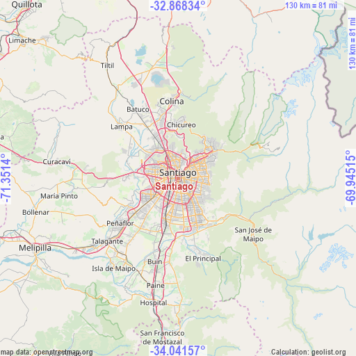
Santiago GPS coordinates[2]
33° 27' 24.984" South, 70° 38' 53.772" West
| Map corner | latitude | longitude |
|---|---|---|
| Upper-left | -32.86834°, | -71.3514° |
| Center: | -33.45694°, | -70.64827° |
| Lower-right: | -34.04157°, | -69.94515° |
| Map W x H: | 130.5×130.5 km | = 81.1×81.1mi |
| max Lat: | -18.19821° ⇑27.6% North |
| Santiago: | -33.45694° |
| min Lat: | ⇓72.4% South -54.93355° |
| min Long | Santiago | max Long |
| -109.42438° | -70.64827° | -67.60963° |
| W 84.8%⇐ | ⇒15.2% E |
Elevation
Elevation of Santiago is 556 m = 1824 ft, and this is 283 m = 928 ft above average elevation for this country.
| Max E: |
3544 m = 11627 ft | 12.4% |
| Santiago | 556 m 1824 ft | |
| Avg. | 273 m = 896 ft | |
Min E: |
1 m = 3 ft | 87.6% |
See also: Santiago elevation on elevation.city.
Geographical zone
Santiago is located in South temperate zone (between Tropic of Capricorn and the Antarctic Circle). Distance of this Southern Tropic circle is 1114.1 km =692.3 mi to North.| Distance of | km | miles | from Santiago |
|---|---|---|---|
| Equator | 3720.1 | 2311.6 | to North |
| Tropic Capricorn | 1114.1 | 692.3 | to North |
| Antarctic Circle | 3681.1 | 2287.3 | to South |
| South Pole | 6287 | 3906.6 | to South |


Nearby cities:
15 places around Santiago: (largest is in red/bold)
• Buin
31.9 km =19.8 mi,  195°
195°
• Chicureo Abajo
19.3 km =12 mi,  358°
358°
• Colina
28.2 km =17.5 mi,  354°
354°
• El Monte
39.8 km =24.7 mi,  231°
231°
• La Pintana
14.1 km =8.8 mi,  174°
174°
• Lampa
28.4 km =17.6 mi,  311°
311°
• Lo Prado
7.3 km =4.5 mi,  281°
281°
• Melipilla
58.5 km =36.4 mi,  243°
243°
• Paine
40 km =24.9 mi,  192°
192°
• Peñaflor
26.9 km =16.7 mi, 231°
• Providencia
5 km =3.1 mi,  54°
54°
• Puente Alto
18.5 km =11.5 mi,  158°
158°
• San Bernardo
15.8 km =9.8 mi, 197°
• Talagante
34.6 km =21.5 mi, 228°
• Villa Presidente Frei, Ñuñoa, Santiago, Chile
6.3 km =3.9 mi,  93°
93°
In other languages:
- In Spanish: Santiago de Chile
- In France: Santiago du Chili
- In German: Santiago de Chile
- In Italian: Santiago del Cile
- In Russian: Сантьяго
- In Chinese: 圣地亚哥
Sources, notices
• [Note1] Compared only with cities in Chile existing in our database
• [Src1] Map data: © OpenStreetMap contributors (CC-BY-SA)
• [Src2] Other city data from geonames.org with taken over terms of usage.
• [Src3] Geographical zone / Annual Mean Temperature by Robert A. Rohde @ Wikipedia
