Melipilla geodata
Melipilla (Santiago Metropolitan) is a seat of a second-order administrative division; located in Chile in America/Santiago (GMT-4) time zone. With population of 63,100 people, there are 35 cities with bigger population in this country. Compared to other cities in Chile, 65.5% of cities are located further ↓South; 65.5% of cities are located further ←West and 56.6% of cities have lower elevation than Melipilla. Note1
Administrative division(s):
- Level 1: Santiago Metropolitan
- Level 2: Provincia de Melipilla
- Level 3: Melipilla


Melipilla GPS coordinates[2]
33° 41' 20.724" South, 71° 12' 55.008" West
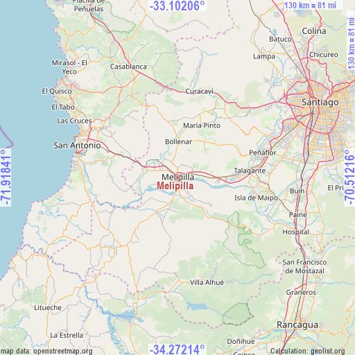
| Map corner | latitude | longitude |
|---|---|---|
| Upper-left | -33.10206°, | -71.91841° |
| Center: | -33.68909°, | -71.21528° |
| Lower-right: | -34.27214°, | -70.51216° |
| Map W x H: | 130.1×130.1 km | = 80.8×80.8mi |
| max Lat: | -18.19821° ⇑34.5% North |
| Melipilla: | -33.68909° |
| min Lat: | ⇓65.5% South -54.93355° |
| min Long | Melipilla | max Long |
| -109.42438° | -71.21528° | -67.60963° |
| W 65.5%⇐ | ⇒34.5% E |
Elevation
Elevation of Melipilla is 175 m = 574 ft, and this is 98 m = 322 ft below average elevation for this country.
| Max E: |
3544 m = 11627 ft | 43.4% |
| Avg. | 273 m = 896 ft | |
| Melipilla | 175 m = 574 ft | |
Min E: |
1 m = 3 ft | 56.6% |
See also: Melipilla elevation on elevation.city.
Geographical zone
Melipilla is located in South temperate zone (between Tropic of Capricorn and the Antarctic Circle). Distance of this Southern Tropic circle is 1140 km =708.4 mi to North.| Distance of | km | miles | from Melipilla |
|---|---|---|---|
| Equator | 3745.9 | 2327.6 | to North |
| Tropic Capricorn | 1140 | 708.4 | to North |
| Antarctic Circle | 3655.3 | 2271.3 | to South |
| South Pole | 6261.2 | 3890.5 | to South |


Nearby cities:
15 places around Melipilla: (largest is in red/bold)
• Buin
44 km =27.3 mi,  96°
96°
• Cartagena
39.3 km =24.4 mi,  292°
292°
• El Monte
21.3 km =13.2 mi,  87°
87°
• El Tabo
49.6 km =30.8 mi,  302°
302°
• Graneros
61.7 km =38.3 mi,  133°
133°
• La Pintana
55.1 km =34.2 mi,  77°
77°
• Lampa
54.8 km =34.1 mi,  35°
35°
• Lo Prado
52.9 km =32.9 mi,  59°
59°
• Paine
45.8 km =28.5 mi,  106°
106°
• Peñaflor
32.7 km =20.3 mi,  73°
73°
• Puente Alto
59.8 km =37.2 mi, 81°
• San Antonio
37.8 km =23.5 mi, 286°
• San Bernardo
48.9 km =30.4 mi, 77°
• Santiago
58.5 km =36.4 mi, 63°
• Talagante
26.8 km =16.7 mi, 83°
Sources, notices
• [Note1] Compared only with cities in Chile existing in our database
• [Src1] Map data: © OpenStreetMap contributors (CC-BY-SA)
• [Src2] Other city data from geonames.org with taken over terms of usage.
• [Src3] Geographical zone / Annual Mean Temperature by Robert A. Rohde @ Wikipedia
