Providencia geodata
Providencia (Santiago Metropolitan) is a seat of a third-order administrative division; located in Chile in America/Santiago (GMT-4) time zone. In our database, there are 135 cities with bigger population. Compared to other cities in Chile, 74.5% of cities are located further ↓South; 86.9% of cities are located further ←West and 91.7% of cities have lower elevation than Providencia. Note1
Administrative division(s):
- Level 1: Santiago Metropolitan
- Level 2: Provincia de Santiago
- Level 3: Providencia


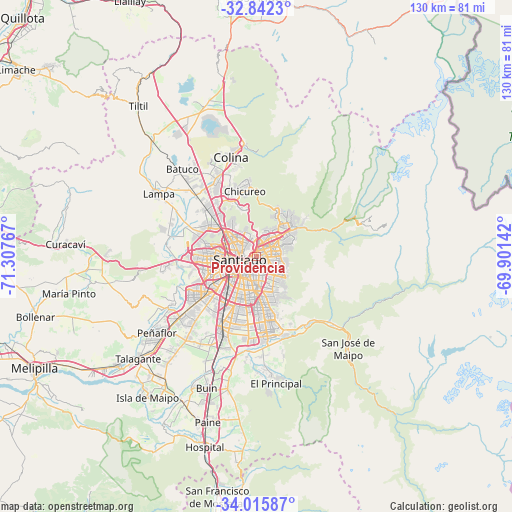
Providencia GPS coordinates[2]
33° 25' 51.852" South, 70° 36' 16.344" West
| Map corner | latitude | longitude |
|---|---|---|
| Upper-left | -32.8423°, | -71.30767° |
| Center: | -33.43107°, | -70.60454° |
| Lower-right: | -34.01587°, | -69.90142° |
| Map W x H: | 130.5×130.5 km | = 81.1×81.1mi |
| max Lat: | -18.19821° ⇑25.5% North |
| Providencia: | -33.43107° |
| min Lat: | ⇓74.5% South -54.93355° |
| min Long | Providencia | max Long |
| -109.42438° | -70.60454° | -67.60963° |
| W 86.9%⇐ | ⇒13.1% E |
Elevation
Elevation of Providencia is 615 m = 2018 ft, and this is 342 m = 1122 ft above average elevation for this country.
| Max E: |
3544 m = 11627 ft | 8.3% |
| Providencia | 615 m 2018 ft | |
| Avg. | 273 m = 896 ft | |
Min E: |
1 m = 3 ft | 91.7% |
See also: Chile elevation on elevation.city.
Geographical zone
Providencia is located in South temperate zone (between Tropic of Capricorn and the Antarctic Circle). Distance of this Southern Tropic circle is 1111.3 km =690.5 mi to North.| Distance of | km | miles | from Providencia |
|---|---|---|---|
| Equator | 3717.2 | 2309.8 | to North |
| Tropic Capricorn | 1111.3 | 690.5 | to North |
| Antarctic Circle | 3684 | 2289.1 | to South |
| South Pole | 6289.9 | 3908.4 | to South |


Nearby cities:
15 places around Providencia: (largest is in red/bold)
• Buin
35.9 km =22.3 mi,  200°
200°
• Chicureo Abajo
17 km =10.6 mi,  344°
344°
• Colina
26 km =16.2 mi,  345°
345°
• El Monte
44.8 km =27.8 mi,  231°
231°
• La Pintana
17.1 km =10.6 mi,  189°
189°
• Lampa
29.9 km =18.6 mi,  302°
302°
• Lo Prado
11.3 km =7 mi,  262°
262°
• Melipilla
63.4 km =39.4 mi,  243°
243°
• Paine
43.8 km =27.2 mi, 196°
• Peñaflor
31.9 km =19.8 mi, 232°
• Puente Alto
20.3 km =12.6 mi,  172°
172°
• San Bernardo
20 km =12.4 mi,  206°
206°
• Santiago
5 km =3.1 mi, 234°
• Talagante
39.6 km =24.6 mi, 229°
• Villa Presidente Frei, Ñuñoa, Santiago, Chile
4 km =2.5 mi,  145°
145°
Sources, notices
• [Note1] Compared only with cities in Chile existing in our database
• [Src1] Map data: © OpenStreetMap contributors (CC-BY-SA)
• [Src2] Other city data from geonames.org with taken over terms of usage.
• [Src3] Geographical zone / Annual Mean Temperature by Robert A. Rohde @ Wikipedia
