Puente Alto geodata
Puente Alto (Santiago Metropolitan) is a seat of a second-order administrative division; located in Chile in America/Santiago (GMT-4) time zone. With population of 510,417 people, there is 1 city with bigger population in this country. Compared to other cities in Chile, 67.6% of cities are located further ↓South; 89% of cities are located further ←West and 94.5% of cities have lower elevation than Puente Alto. Note1
Administrative division(s):
- Level 1: Santiago Metropolitan
- Level 2: Provincia de Cordillera
- Level 3: Puente Alto


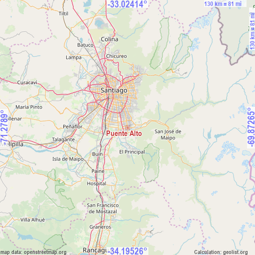
Puente Alto GPS coordinates[2]
33° 36' 42.084" South, 70° 34' 32.772" West
| Map corner | latitude | longitude |
|---|---|---|
| Upper-left | -33.02414°, | -71.2789° |
| Center: | -33.61169°, | -70.57577° |
| Lower-right: | -34.19526°, | -69.87265° |
| Map W x H: | 130.2×130.2 km | = 80.9×80.9mi |
| max Lat: | -18.19821° ⇑32.4% North |
| Puente Alto: | -33.61169° |
| min Lat: | ⇓67.6% South -54.93355° |
| min Long | Puente Alto | max Long |
| -109.42438° | -70.57577° | -67.60963° |
| W 89%⇐ | ⇒11% E |
Elevation
Elevation of Puente Alto is 700 m = 2297 ft, and this is 427 m = 1401 ft above average elevation for this country.
| Max E: |
3544 m = 11627 ft | 5.5% |
| Puente Alto | 700 m 2297 ft | |
| Avg. | 273 m = 896 ft | |
Min E: |
1 m = 3 ft | 94.5% |
See also: Puente Alto elevation on elevation.city.
Geographical zone
Puente Alto is located in South temperate zone (between Tropic of Capricorn and the Antarctic Circle). Distance of this Southern Tropic circle is 1131.4 km =703 mi to North.| Distance of | km | miles | from Puente Alto |
|---|---|---|---|
| Equator | 3737.3 | 2322.2 | to North |
| Tropic Capricorn | 1131.4 | 703 | to North |
| Antarctic Circle | 3663.9 | 2276.6 | to South |
| South Pole | 6269.8 | 3895.9 | to South |


Nearby cities:
15 places around Puente Alto: (largest is in red/bold)
• Buin
20.5 km =12.7 mi,  228°
228°
• Chicureo Abajo
37.2 km =23.1 mi,  348°
348°
• Colina
46.2 km =28.7 mi, 348°
• El Monte
38.6 km =24 mi,  258°
258°
• Graneros
52.7 km =32.7 mi,  195°
195°
• La Pintana
6.3 km =3.9 mi,  300°
300°
• Lampa
45.6 km =28.3 mi,  322°
322°
• Lo Prado
23.2 km =14.4 mi, 323°
• Paine
26.6 km =16.5 mi,  215°
215°
• Peñaflor
27.9 km =17.3 mi,  271°
271°
• Providencia
20.3 km =12.6 mi, 352°
• San Bernardo
11.7 km =7.3 mi,  280°
280°
• Santiago
18.5 km =11.5 mi,  338°
338°
• Talagante
33.1 km =20.6 mi, 259°
• Villa Presidente Frei, Ñuñoa, Santiago, Chile
16.8 km =10.4 mi,  358°
358°
Sources, notices
• [Note1] Compared only with cities in Chile existing in our database
• [Src1] Map data: © OpenStreetMap contributors (CC-BY-SA)
• [Src2] Other city data from geonames.org with taken over terms of usage.
• [Src3] Geographical zone / Annual Mean Temperature by Robert A. Rohde @ Wikipedia
