Muyuka geodata
Muyuka (South-West) is a populated place; located in Cameroon in Africa/Douala (GMT+1) time zone. With population of 31,384 people, there are 46 cities with bigger population in this country. Compared to other cities in Cameroon, 70.5% of cities are located further ↑North; 93.4% of cities are located further →East and 94.3% of cities have higher elevation than Muyuka. Note1


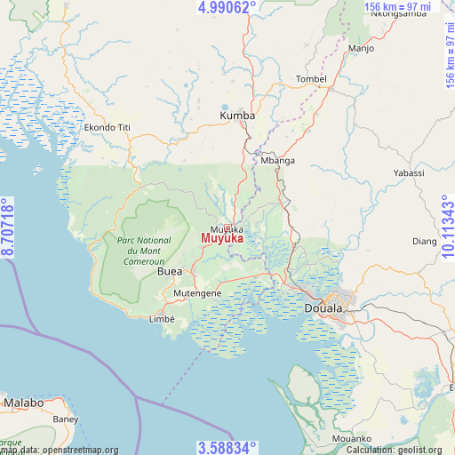
Muyuka GPS coordinates[2]
4° 17' 23.28" North, 9° 24' 37.08" East
| Map corner | latitude | longitude |
|---|---|---|
| Upper-left | 4.99062°, | 8.70718° |
| Center: | 4.2898°, | 9.4103° |
| Lower-right: | 3.58834°, | 10.11343° |
| Map W x H: | 155.9×155.9 km | = 96.9×96.9mi |
| max Lat: | 12.57535° ⇑70.5% North |
| Muyuka: | 4.2898° |
| min Lat: | ⇓29.5% South 2.35° |
| min Long | Muyuka | max Long |
| 8.8724° | 9.4103° | 15.23288° |
| W 6.6%⇐ | ⇒93.4% E |
Elevation
Elevation of Muyuka is 41 m = 135 ft, and this is 632.9 m = 2076 ft below average elevation for this country.
| Max E: |
1687 m = 5535 ft | 94.3% |
| Avg. | 673.9 m = 2211 ft | |
| Muyuka | 41 m = 135 ft | |
Min E: |
1 m = 3 ft | 5.7% |
See also: Cameroon elevation on elevation.city.
Geographical zone
Muyuka is located in North Torrid zone (between Equator and Tropic of Cancer). Distance of Equator is 477 km =296.4 mi to South.| Distance of | km | miles | from Muyuka |
|---|---|---|---|
| North Pole | 9530.1 | 5921.7 | to North |
| Arctic Circle | 6924.2 | 4302.5 | to North |
| Tropic Cancer | 2128.9 | 1322.8 | to North |
| Equator | 477 | 296.4 | to South |


Nearby cities:
15 places around Muyuka: (largest is in red/bold)
• Bamusso
59.3 km =36.8 mi,  288°
288°
• Bekondo
44.7 km =27.8 mi,  347°
347°
• Bonabéri
38.7 km =24 mi,  128°
128°
• Buea
24 km =14.9 mi,  230°
230°
• Dibombari
29.9 km =18.6 mi,  114°
114°
• Douala
42.2 km =26.2 mi, 129°
• Kumba
38.7 km =24 mi,  6°
6°
• Limbe
37.3 km =23.2 mi,  217°
217°
• Loum
59.7 km =37.1 mi,  37°
37°
• Mbanga
29.3 km =18.2 mi, 36°
• Mutengene
24.5 km =15.2 mi,  205°
205°
• Ndom
28.6 km =17.8 mi, 36°
• Penja
49 km =30.4 mi, 37°
• Tiko
24.5 km =15.2 mi,  193°
193°
• Yabassi
64.6 km =40.1 mi,  73°
73°
Sources, notices
• [Note1] Compared only with cities in Cameroon existing in our database
• [Src1] Map data: © OpenStreetMap contributors (CC-BY-SA)
• [Src2] Other city data from geonames.org with taken over terms of usage.
• [Src3] Geographical zone / Annual Mean Temperature by Robert A. Rohde @ Wikipedia
