Bekondo geodata
Bekondo (South-West) is a populated place; located in Cameroon in Africa/Douala (GMT+1) time zone. With population of 7,331 people, there are 85 cities with bigger population in this country. Compared to other cities in Cameroon, 56.6% of cities are located further ↑North; 95.1% of cities are located further →East and 73% of cities have higher elevation than Bekondo. Note1


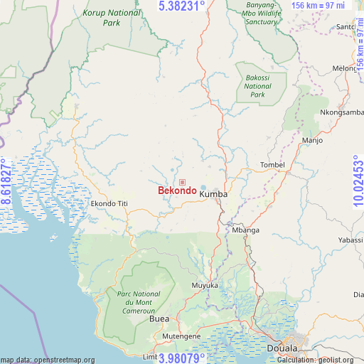
Bekondo GPS coordinates[2]
4° 40' 54.84" North, 9° 19' 17.04" East
| Map corner | latitude | longitude |
|---|---|---|
| Upper-left | 5.38231°, | 8.61827° |
| Center: | 4.6819°, | 9.3214° |
| Lower-right: | 3.98079°, | 10.02453° |
| Map W x H: | 155.8×155.8 km | = 96.8×96.8mi |
| max Lat: | 12.57535° ⇑56.6% North |
| Bekondo: | 4.6819° |
| min Lat: | ⇓43.4% South 2.35° |
| min Long | Bekondo | max Long |
| 8.8724° | 9.3214° | 15.23288° |
| W 4.9%⇐ | ⇒95.1% E |
Elevation
Elevation of Bekondo is 382 m = 1253 ft, and this is 291.9 m = 958 ft below average elevation for this country.
| Max E: |
1687 m = 5535 ft | 73% |
| Avg. | 673.9 m = 2211 ft | |
| Bekondo | 382 m = 1253 ft | |
Min E: |
1 m = 3 ft | 27% |
See also: Cameroon elevation on elevation.city.
Geographical zone
Bekondo is located in North Torrid zone (between Equator and Tropic of Cancer). Distance of Equator is 520.6 km =323.5 mi to South.| Distance of | km | miles | from Bekondo |
|---|---|---|---|
| North Pole | 9486.5 | 5894.6 | to North |
| Arctic Circle | 6880.6 | 4275.4 | to North |
| Tropic Cancer | 2085.3 | 1295.7 | to North |
| Equator | 520.6 | 323.5 | to South |


Nearby cities:
15 places around Bekondo: (largest is in red/bold)
• Bamusso
52.6 km =32.7 mi,  241°
241°
• Buea
59.4 km =36.9 mi,  188°
188°
• Dibombari
67.1 km =41.7 mi,  146°
146°
• Kumba
14.8 km =9.2 mi,  110°
110°
• Limbe
74.3 km =46.2 mi, 189°
• Loum
46 km =28.6 mi,  84°
84°
• Manjo
58.3 km =36.2 mi,  72°
72°
• Mbanga
33.8 km =21 mi,  126°
126°
• Mundemba
57.9 km =36 mi,  300°
300°
• Mutengene
65.7 km =40.8 mi,  180°
180°
• Muyuka
44.7 km =27.8 mi,  167°
167°
• Ndom
33.7 km =20.9 mi, 127°
• Nguti
72.8 km =45.2 mi,  8°
8°
• Penja
40 km =24.9 mi,  96°
96°
• Tiko
67.6 km =42 mi, 176°
Sources, notices
• [Note1] Compared only with cities in Cameroon existing in our database
• [Src1] Map data: © OpenStreetMap contributors (CC-BY-SA)
• [Src2] Other city data from geonames.org with taken over terms of usage.
• [Src3] Geographical zone / Annual Mean Temperature by Robert A. Rohde @ Wikipedia
