Douala geodata
Douala (Littoral) is a seat of a first-order administrative division; located in Cameroon in Africa/Douala (GMT+1) time zone. With population of 1,338,082 people, there are 0 cities with bigger population in this country. Compared to other cities in Cameroon, 80.3% of cities are located further ↑North; 86.9% of cities are located further →East and 96.7% of cities have higher elevation than Douala. Note1


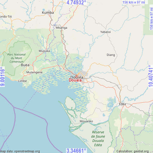
Douala GPS coordinates[2]
4° 2' 53.772" North, 9° 42' 15.408" East
| Map corner | latitude | longitude |
|---|---|---|
| Upper-left | 4.74932°, | 9.00116° |
| Center: | 4.04827°, | 9.70428° |
| Lower-right: | 3.34661°, | 10.40741° |
| Map W x H: | 156×156 km | = 96.9×96.9mi |
| max Lat: | 12.57535° ⇑80.3% North |
| Douala: | 4.04827° |
| min Lat: | ⇓19.7% South 2.35° |
| min Long | Douala | max Long |
| 8.8724° | 9.70428° | 15.23288° |
| W 13.1%⇐ | ⇒86.9% E |
Elevation
Elevation of Douala is 19 m = 62 ft, and this is 654.9 m = 2149 ft below average elevation for this country.
| Max E: |
1687 m = 5535 ft | 96.7% |
| Avg. | 673.9 m = 2211 ft | |
| Douala | 19 m = 62 ft | |
Min E: |
1 m = 3 ft | 3.3% |
See also: Douala elevation on elevation.city.
Geographical zone
Douala is located in North Torrid zone (between Equator and Tropic of Cancer). Distance of Equator is 450.1 km =279.7 mi to South.| Distance of | km | miles | from Douala |
|---|---|---|---|
| North Pole | 9556.9 | 5938.4 | to North |
| Arctic Circle | 6951 | 4319.1 | to North |
| Tropic Cancer | 2155.8 | 1339.6 | to North |
| Equator | 450.1 | 279.7 | to South |


Nearby cities:
15 places around Douala: (largest is in red/bold)
• Bonabéri
3.6 km =2.2 mi,  315°
315°
• Buea
52.6 km =32.7 mi,  282°
282°
• Diang
41.3 km =25.7 mi,  57°
57°
• Dibombari
15.5 km =9.6 mi,  339°
339°
• Dizangué
44 km =27.3 mi,  135°
135°
• Edéa
55 km =34.2 mi,  120°
120°
• Limbe
55.3 km =34.4 mi,  267°
267°
• Mbanga
52.7 km =32.7 mi, 343°
• Mouanko
46.1 km =28.6 mi,  169°
169°
• Mutengene
43.5 km =27 mi, 276°
• Muyuka
42.2 km =26.2 mi,  309°
309°
• Ndom
52.4 km =32.6 mi, 342°
• Penja
65.8 km =40.9 mi,  357°
357°
• Tiko
38.3 km =23.8 mi, 274°
• Yabassi
54.1 km =33.6 mi,  32°
32°
Sources, notices
• [Note1] Compared only with cities in Cameroon existing in our database
• [Src1] Map data: © OpenStreetMap contributors (CC-BY-SA)
• [Src2] Other city data from geonames.org with taken over terms of usage.
• [Src3] Geographical zone / Annual Mean Temperature by Robert A. Rohde @ Wikipedia
