Mutengene geodata
Mutengene (South-West) is a populated place; located in Cameroon in Africa/Douala (GMT+1) time zone. With population of 47,478 people, there are 35 cities with bigger population in this country. Compared to other cities in Cameroon, 77% of cities are located further ↑North; 95.9% of cities are located further →East and 80.3% of cities have higher elevation than Mutengene. Note1


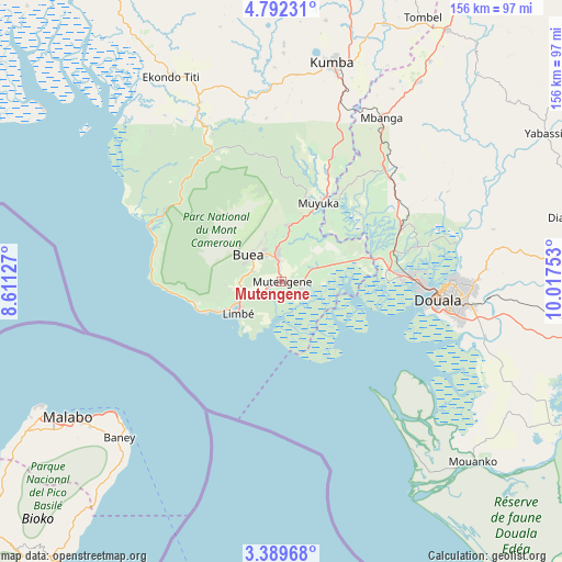
Mutengene GPS coordinates[2]
4° 5' 28.68" North, 9° 18' 51.84" East
| Map corner | latitude | longitude |
|---|---|---|
| Upper-left | 4.79231°, | 8.61127° |
| Center: | 4.0913°, | 9.3144° |
| Lower-right: | 3.38968°, | 10.01753° |
| Map W x H: | 156×156 km | = 96.9×96.9mi |
| max Lat: | 12.57535° ⇑77% North |
| Mutengene: | 4.0913° |
| min Lat: | ⇓23% South 2.35° |
| min Long | Mutengene | max Long |
| 8.8724° | 9.3144° | 15.23288° |
| W 4.1%⇐ | ⇒95.9% E |
Elevation
Elevation of Mutengene is 241 m = 791 ft, and this is 432.9 m = 1420 ft below average elevation for this country.
| Max E: |
1687 m = 5535 ft | 80.3% |
| Avg. | 673.9 m = 2211 ft | |
| Mutengene | 241 m = 791 ft | |
Min E: |
1 m = 3 ft | 19.7% |
See also: Mutengene elevation on elevation.city.
Geographical zone
Mutengene is located in North Torrid zone (between Equator and Tropic of Cancer). Distance of Equator is 454.9 km =282.7 mi to South.| Distance of | km | miles | from Mutengene |
|---|---|---|---|
| North Pole | 9552.2 | 5935.5 | to North |
| Arctic Circle | 6946.3 | 4316.2 | to North |
| Tropic Cancer | 2151 | 1336.6 | to North |
| Equator | 454.9 | 282.7 | to South |


Nearby cities:
15 places around Mutengene: (largest is in red/bold)
• Bamusso
61.3 km =38.1 mi,  311°
311°
• Bekondo
65.7 km =40.8 mi,  0°
0°
• Bonabéri
40.8 km =25.4 mi,  93°
93°
• Buea
10.6 km =6.6 mi, 310°
• Diang
79.9 km =49.6 mi,  77°
77°
• Dibombari
39.1 km =24.3 mi, 75°
• Douala
43.5 km =27 mi,  96°
96°
• Kumba
62.4 km =38.8 mi,  13°
13°
• Limbe
14.2 km =8.8 mi,  237°
237°
• Mbanga
53.5 km =33.2 mi,  31°
31°
• Mouanko
71.8 km =44.6 mi,  134°
134°
• Muyuka
24.5 km =15.2 mi, 25°
• Ndom
52.9 km =32.9 mi, 31°
• Penja
73.2 km =45.5 mi, 33°
• Tiko
5.4 km =3.4 mi,  109°
109°
Sources, notices
• [Note1] Compared only with cities in Cameroon existing in our database
• [Src1] Map data: © OpenStreetMap contributors (CC-BY-SA)
• [Src2] Other city data from geonames.org with taken over terms of usage.
• [Src3] Geographical zone / Annual Mean Temperature by Robert A. Rohde @ Wikipedia
