Penja geodata
Penja (Littoral) is a populated place; located in Cameroon in Africa/Douala (GMT+1) time zone. With population of 28,406 people, there are 49 cities with bigger population in this country. Compared to other cities in Cameroon, 57.4% of cities are located further ↑North; 88.5% of cities are located further →East and 86.1% of cities have higher elevation than Penja. Note1


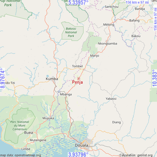
Penja GPS coordinates[2]
4° 38' 20.796" North, 9° 40' 47.532" East
| Map corner | latitude | longitude |
|---|---|---|
| Upper-left | 5.33957°, | 8.97674° |
| Center: | 4.63911°, | 9.67987° |
| Lower-right: | 3.93796°, | 10.383° |
| Map W x H: | 155.8×155.8 km | = 96.8×96.8mi |
| max Lat: | 12.57535° ⇑57.4% North |
| Penja: | 4.63911° |
| min Lat: | ⇓42.6% South 2.35° |
| min Long | Penja | max Long |
| 8.8724° | 9.67987° | 15.23288° |
| W 11.5%⇐ | ⇒88.5% E |
Elevation
Elevation of Penja is 148 m = 486 ft, and this is 525.9 m = 1725 ft below average elevation for this country.
| Max E: |
1687 m = 5535 ft | 86.1% |
| Avg. | 673.9 m = 2211 ft | |
| Penja | 148 m = 486 ft | |
Min E: |
1 m = 3 ft | 13.9% |
See also: Cameroon elevation on elevation.city.
Geographical zone
Penja is located in North Torrid zone (between Equator and Tropic of Cancer). Distance of Equator is 515.8 km =320.5 mi to South.| Distance of | km | miles | from Penja |
|---|---|---|---|
| North Pole | 9491.2 | 5897.6 | to North |
| Arctic Circle | 6885.4 | 4278.4 | to North |
| Tropic Cancer | 2090.1 | 1298.7 | to North |
| Equator | 515.8 | 320.5 | to South |


Nearby cities:
15 places around Penja: (largest is in red/bold)
• Bekondo
40 km =24.9 mi,  276°
276°
• Bonabéri
63.1 km =39.2 mi,  179°
179°
• Diang
57.1 km =35.5 mi,  139°
139°
• Dibombari
51.3 km =31.9 mi, 182°
• Douala
65.8 km =40.9 mi, 177°
• Kumba
25.8 km =16 mi,  269°
269°
• Loum
10.7 km =6.6 mi,  34°
34°
• Manjo
27.6 km =17.1 mi, 34°
• Mbanga
19.7 km =12.2 mi,  219°
219°
• Melong
62.1 km =38.6 mi, 30°
• Muyuka
49 km =30.4 mi, 217°
• Ndom
20.4 km =12.7 mi, 219°
• Nkongsamba
45.4 km =28.2 mi,  39°
39°
• Tiko
72.1 km =44.8 mi,  209°
209°
• Yabassi
37.8 km =23.5 mi,  122°
122°
Sources, notices
• [Note1] Compared only with cities in Cameroon existing in our database
• [Src1] Map data: © OpenStreetMap contributors (CC-BY-SA)
• [Src2] Other city data from geonames.org with taken over terms of usage.
• [Src3] Geographical zone / Annual Mean Temperature by Robert A. Rohde @ Wikipedia
