Yabassi geodata
Yabassi (Littoral) is a populated place; located in Cameroon in Africa/Douala (GMT+1) time zone. With population of 7,560 people, there are 82 cities with bigger population in this country. Compared to other cities in Cameroon, 65.6% of cities are located further ↑North; 79.5% of cities are located further →East and 93.4% of cities have higher elevation than Yabassi. Note1


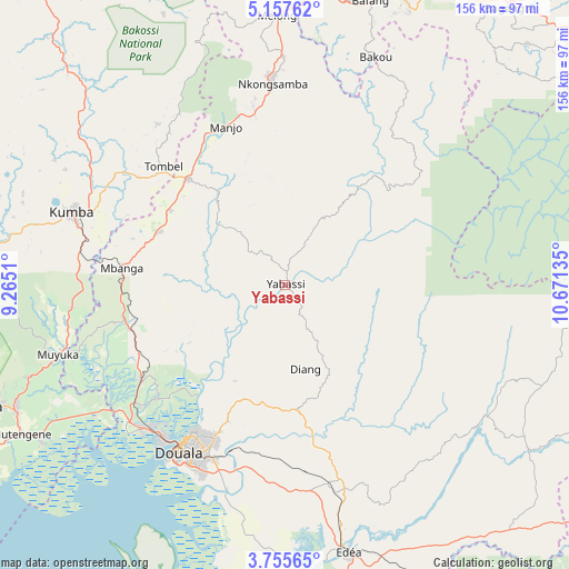
Yabassi GPS coordinates[2]
4° 27' 25.092" North, 9° 58' 5.592" East
| Map corner | latitude | longitude |
|---|---|---|
| Upper-left | 5.15762°, | 9.2651° |
| Center: | 4.45697°, | 9.96822° |
| Lower-right: | 3.75565°, | 10.67135° |
| Map W x H: | 155.9×155.9 km | = 96.9×96.9mi |
| max Lat: | 12.57535° ⇑65.6% North |
| Yabassi: | 4.45697° |
| min Lat: | ⇓34.4% South 2.35° |
| min Long | Yabassi | max Long |
| 8.8724° | 9.96822° | 15.23288° |
| W 20.5%⇐ | ⇒79.5% E |
Elevation
Elevation of Yabassi is 49 m = 161 ft, and this is 624.9 m = 2050 ft below average elevation for this country.
| Max E: |
1687 m = 5535 ft | 93.4% |
| Avg. | 673.9 m = 2211 ft | |
| Yabassi | 49 m = 161 ft | |
Min E: |
1 m = 3 ft | 6.6% |
See also: Cameroon elevation on elevation.city.
Geographical zone
Yabassi is located in North Torrid zone (between Equator and Tropic of Cancer). Distance of Equator is 495.6 km =308 mi to South.| Distance of | km | miles | from Yabassi |
|---|---|---|---|
| North Pole | 9511.5 | 5910.2 | to North |
| Arctic Circle | 6905.6 | 4290.9 | to North |
| Tropic Cancer | 2110.4 | 1311.3 | to North |
| Equator | 495.6 | 308 | to South |


Nearby cities:
15 places around Yabassi: (largest is in red/bold)
• Bonabéri
53.4 km =33.2 mi,  216°
216°
• Diang
23.6 km =14.7 mi,  166°
166°
• Dibombari
46.4 km =28.8 mi,  228°
228°
• Douala
54.1 km =33.6 mi,  212°
212°
• Edéa
75.3 km =46.8 mi, 165°
• Kumba
61.1 km =38 mi,  289°
289°
• Loum
38.9 km =24.2 mi,  318°
318°
• Manjo
45.9 km =28.5 mi,  339°
339°
• Mbanga
44.7 km =27.8 mi,  276°
276°
• Melong
73.9 km =45.9 mi,  359°
359°
• Muyuka
64.6 km =40.1 mi,  253°
253°
• Ndom
45.2 km =28.1 mi, 275°
• Ngambé
75.9 km =47.2 mi,  109°
109°
• Nkongsamba
55.4 km =34.4 mi, 356°
• Penja
37.8 km =23.5 mi,  302°
302°
Sources, notices
• [Note1] Compared only with cities in Cameroon existing in our database
• [Src1] Map data: © OpenStreetMap contributors (CC-BY-SA)
• [Src2] Other city data from geonames.org with taken over terms of usage.
• [Src3] Geographical zone / Annual Mean Temperature by Robert A. Rohde @ Wikipedia
