Batibo geodata
Batibo (North-West) is a populated place; located in Cameroon in Africa/Douala (GMT+1) time zone. With population of 9,163 people, there are 74 cities with bigger population in this country. Compared to other cities in Cameroon, 68% of cities are located further ↓South; 83.6% of cities are located further →East and 78.7% of cities have lower elevation than Batibo. Note1


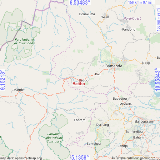
Batibo GPS coordinates[2]
5° 50' 8.88" North, 9° 51' 19.08" East
| Map corner | latitude | longitude |
|---|---|---|
| Upper-left | 6.53483°, | 9.15218° |
| Center: | 5.8358°, | 9.8553° |
| Lower-right: | 5.1359°, | 10.55843° |
| Map W x H: | 155.5×155.5 km | = 96.6×96.6mi |
| max Lat: | 12.57535° ⇑32% North |
| Batibo: | 5.8358° |
| min Lat: | ⇓68% South 2.35° |
| min Long | Batibo | max Long |
| 8.8724° | 9.8553° | 15.23288° |
| W 16.4%⇐ | ⇒83.6% E |
Elevation
Elevation of Batibo is 1090 m = 3576 ft, and this is 416.1 m = 1365 ft above average elevation for this country.
| Max E: |
1687 m = 5535 ft | 21.3% |
| Batibo | 1090 m 3576 ft | |
| Avg. | 673.9 m = 2211 ft | |
Min E: |
1 m = 3 ft | 78.7% |
See also: Cameroon elevation on elevation.city.
Geographical zone
Batibo is located in North Torrid zone (between Equator and Tropic of Cancer). Distance of Equator is 648.9 km =403.2 mi to South.| Distance of | km | miles | from Batibo |
|---|---|---|---|
| North Pole | 9358.2 | 5814.9 | to North |
| Arctic Circle | 6752.3 | 4195.7 | to North |
| Tropic Cancer | 1957 | 1216 | to North |
| Equator | 648.9 | 403.2 | to South |


Nearby cities:
15 places around Batibo: (largest is in red/bold)
• Babanki
53.7 km =33.4 mi,  54°
54°
• Bali
18.2 km =11.3 mi,  71°
71°
• Bamenda
35 km =21.7 mi, 66°
• Bamendjou
72.2 km =44.9 mi,  133°
133°
• Bansoa
66.5 km =41.3 mi, 130°
• Belo
54.8 km =34.1 mi, 52°
• Dschang
48.8 km =30.3 mi,  153°
153°
• Fontem
40.9 km =25.4 mi,  175°
175°
• Fundong
64.7 km =40.2 mi,  44°
44°
• Mamfe
60.6 km =37.7 mi,  261°
261°
• Mbengwi
25.7 km =16 mi, 38°
• Mbouda
49.9 km =31 mi,  117°
117°
• Mme-Bafumen
69.3 km =43.1 mi, 37°
• Njinikom
64.8 km =40.3 mi, 46°
• Wum
65.2 km =40.5 mi,  20°
20°
Sources, notices
• [Note1] Compared only with cities in Cameroon existing in our database
• [Src1] Map data: © OpenStreetMap contributors (CC-BY-SA)
• [Src2] Other city data from geonames.org with taken over terms of usage.
• [Src3] Geographical zone / Annual Mean Temperature by Robert A. Rohde @ Wikipedia
