Fontem geodata
Fontem (South-West) is a populated place; located in Cameroon in Africa/Douala (GMT+1) time zone. With population of 42,689 people, there are 40 cities with bigger population in this country. Compared to other cities in Cameroon, 61.5% of cities are located further ↓South; 82.8% of cities are located further →East and 73% of cities have lower elevation than Fontem. Note1


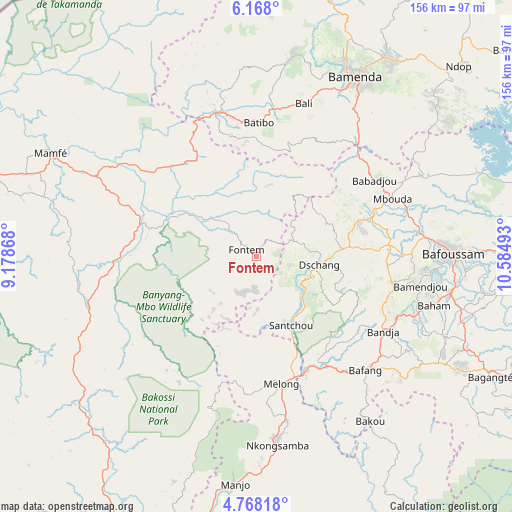
Fontem GPS coordinates[2]
5° 28' 6.6" North, 9° 52' 54.48" East
| Map corner | latitude | longitude |
|---|---|---|
| Upper-left | 6.168°, | 9.17868° |
| Center: | 5.4685°, | 9.8818° |
| Lower-right: | 4.76818°, | 10.58493° |
| Map W x H: | 155.6×155.6 km | = 96.7×96.7mi |
| max Lat: | 12.57535° ⇑38.5% North |
| Fontem: | 5.4685° |
| min Lat: | ⇓61.5% South 2.35° |
| min Long | Fontem | max Long |
| 8.8724° | 9.8818° | 15.23288° |
| W 17.2%⇐ | ⇒82.8% E |
Elevation
Elevation of Fontem is 902 m = 2959 ft, and this is 228.1 m = 748 ft above average elevation for this country.
| Max E: |
1687 m = 5535 ft | 27% |
| Fontem | 902 m 2959 ft | |
| Avg. | 673.9 m = 2211 ft | |
Min E: |
1 m = 3 ft | 73% |
See also: Fontem elevation on elevation.city.
Geographical zone
Fontem is located in North Torrid zone (between Equator and Tropic of Cancer). Distance of Equator is 608 km =377.8 mi to South.| Distance of | km | miles | from Fontem |
|---|---|---|---|
| North Pole | 9399 | 5840.3 | to North |
| Arctic Circle | 6793.1 | 4221 | to North |
| Tropic Cancer | 1997.9 | 1241.4 | to North |
| Equator | 608 | 377.8 | to South |


Nearby cities:
15 places around Fontem: (largest is in red/bold)
• Bafang
47.6 km =29.6 mi,  136°
136°
• Bafoussam
59.3 km =36.8 mi,  89°
89°
• Bali
48.7 km =30.3 mi,  17°
17°
• Bamenda
61.9 km =38.5 mi,  28°
28°
• Bamendjou
50.4 km =31.3 mi,  99°
99°
• Bana
56.4 km =35 mi,  129°
129°
• Bandjoun
59.7 km =37.1 mi, 99°
• Bansoa
47.8 km =29.7 mi, 92°
• Batibo
40.9 km =25.4 mi,  355°
355°
• Dschang
19.2 km =11.9 mi, 98°
• Mbengwi
62.3 km =38.7 mi,  12°
12°
• Mbouda
44.8 km =27.8 mi,  66°
66°
• Melong
39.5 km =24.5 mi,  167°
167°
• Nguti
53.6 km =33.3 mi,  253°
253°
• Nkongsamba
57.5 km =35.7 mi, 173°
Sources, notices
• [Note1] Compared only with cities in Cameroon existing in our database
• [Src1] Map data: © OpenStreetMap contributors (CC-BY-SA)
• [Src2] Other city data from geonames.org with taken over terms of usage.
• [Src3] Geographical zone / Annual Mean Temperature by Robert A. Rohde @ Wikipedia
