Dschang geodata
Dschang (West) is a populated place; located in Cameroon in Africa/Douala (GMT+1) time zone. With population of 96,112 people, there are 15 cities with bigger population in this country. Compared to other cities in Cameroon, 59.8% of cities are located further ↓South; 75.4% of cities are located further →East and 89.3% of cities have lower elevation than Dschang. Note1


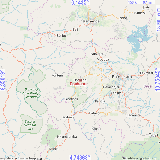
Dschang GPS coordinates[2]
5° 26' 38.292" North, 10° 3' 11.952" East
| Map corner | latitude | longitude |
|---|---|---|
| Upper-left | 6.1435°, | 9.35019° |
| Center: | 5.44397°, | 10.05332° |
| Lower-right: | 4.74363°, | 10.75645° |
| Map W x H: | 155.7×155.7 km | = 96.7×96.7mi |
| max Lat: | 12.57535° ⇑40.2% North |
| Dschang: | 5.44397° |
| min Lat: | ⇓59.8% South 2.35° |
| min Long | Dschang | max Long |
| 8.8724° | 10.05332° | 15.23288° |
| W 24.6%⇐ | ⇒75.4% E |
Elevation
Elevation of Dschang is 1345 m = 4413 ft, and this is 671.1 m = 2202 ft above average elevation for this country.
| Max E: |
1687 m = 5535 ft | 10.7% |
| Dschang | 1345 m 4413 ft | |
| Avg. | 673.9 m = 2211 ft | |
Min E: |
1 m = 3 ft | 89.3% |
See also: Dschang elevation on elevation.city.
Geographical zone
Dschang is located in North Torrid zone (between Equator and Tropic of Cancer). Distance of Equator is 605.3 km =376.1 mi to South.| Distance of | km | miles | from Dschang |
|---|---|---|---|
| North Pole | 9401.7 | 5841.9 | to North |
| Arctic Circle | 6795.9 | 4222.8 | to North |
| Tropic Cancer | 2000.6 | 1243.1 | to North |
| Equator | 605.3 | 376.1 | to South |


Nearby cities:
15 places around Dschang: (largest is in red/bold)
• Bafang
34.7 km =21.6 mi,  156°
156°
• Bafoussam
40.5 km =25.2 mi,  84°
84°
• Bali
49.5 km =30.8 mi,  354°
354°
• Bamenda
58.3 km =36.2 mi,  10°
10°
• Bamendjou
31.2 km =19.4 mi,  101°
101°
• Bana
41.2 km =25.6 mi,  143°
143°
• Bandjoun
40.6 km =25.2 mi, 100°
• Bangangté
62.2 km =38.6 mi,  122°
122°
• Bansoa
28.8 km =17.9 mi,  89°
89°
• Batibo
48.8 km =30.3 mi,  333°
333°
• Fontem
19.2 km =11.9 mi,  278°
278°
• Mbouda
30.1 km =18.7 mi,  47°
47°
• Melong
37.2 km =23.1 mi,  195°
195°
• Ngou
45.9 km =28.5 mi,  126°
126°
• Nkongsamba
55.8 km =34.7 mi,  192°
192°
In other languages:
- In France: Dschang, Tchang, Djang, Dchang, Chang
- In Russian: Джанг
- In Chinese: 姜鎮
Sources, notices
• [Note1] Compared only with cities in Cameroon existing in our database
• [Src1] Map data: © OpenStreetMap contributors (CC-BY-SA)
• [Src2] Other city data from geonames.org with taken over terms of usage.
• [Src3] Geographical zone / Annual Mean Temperature by Robert A. Rohde @ Wikipedia
