Bamenda geodata
Bamenda (North-West) is a seat of a first-order administrative division; located in Cameroon in Africa/Douala (GMT+1) time zone. With population of 393,835 people, there are 4 cities with bigger population in this country. Compared to other cities in Cameroon, 70.5% of cities are located further ↓South; 73% of cities are located further →East and 86.1% of cities have lower elevation than Bamenda. Note1


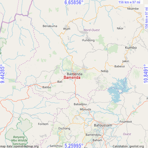
Bamenda GPS coordinates[2]
5° 57' 34.92" North, 10° 8' 45.492" East
| Map corner | latitude | longitude |
|---|---|---|
| Upper-left | 6.65856°, | 9.44285° |
| Center: | 5.9597°, | 10.14597° |
| Lower-right: | 5.25995°, | 10.8491° |
| Map W x H: | 155.5×155.5 km | = 96.6×96.6mi |
| max Lat: | 12.57535° ⇑29.5% North |
| Bamenda: | 5.9597° |
| min Lat: | ⇓70.5% South 2.35° |
| min Long | Bamenda | max Long |
| 8.8724° | 10.14597° | 15.23288° |
| W 27%⇐ | ⇒73% E |
Elevation
Elevation of Bamenda is 1258 m = 4127 ft, and this is 584.1 m = 1916 ft above average elevation for this country.
| Max E: |
1687 m = 5535 ft | 13.9% |
| Bamenda | 1258 m 4127 ft | |
| Avg. | 673.9 m = 2211 ft | |
Min E: |
1 m = 3 ft | 86.1% |
See also: Bamenda elevation on elevation.city.
Geographical zone
Bamenda is located in North Torrid zone (between Equator and Tropic of Cancer). Distance of Equator is 662.7 km =411.8 mi to South.| Distance of | km | miles | from Bamenda |
|---|---|---|---|
| North Pole | 9344.4 | 5806.3 | to North |
| Arctic Circle | 6738.5 | 4187.1 | to North |
| Tropic Cancer | 1943.3 | 1207.5 | to North |
| Equator | 662.7 | 411.8 | to South |


Nearby cities:
15 places around Bamenda: (largest is in red/bold)
• Babanki
20.9 km =13 mi,  33°
33°
• Bafoussam
61.4 km =38.2 mi,  150°
150°
• Bali
16.9 km =10.5 mi,  241°
241°
• Bansoa
59.8 km =37.2 mi,  161°
161°
• Batibo
35 km =21.7 mi,  246°
246°
• Belo
22.5 km =14 mi, 30°
• Dschang
58.3 km =36.2 mi,  190°
190°
• Fontem
61.9 km =38.5 mi,  208°
208°
• Fundong
34.9 km =21.7 mi,  22°
22°
• Jakiri
57.9 km =36 mi,  74°
74°
• Mbengwi
17.3 km =10.7 mi,  291°
291°
• Mbouda
39 km =24.2 mi, 162°
• Mme-Bafumen
42.7 km =26.5 mi,  13°
13°
• Njinikom
34 km =21.1 mi, 26°
• Wum
47.9 km =29.8 mi,  349°
349°
Sources, notices
• [Note1] Compared only with cities in Cameroon existing in our database
• [Src1] Map data: © OpenStreetMap contributors (CC-BY-SA)
• [Src2] Other city data from geonames.org with taken over terms of usage.
• [Src3] Geographical zone / Annual Mean Temperature by Robert A. Rohde @ Wikipedia
