Mamfe geodata
Mamfe (South-West) is a populated place; located in Cameroon in Africa/Douala (GMT+1) time zone. With population of 19,472 people, there are 58 cities with bigger population in this country. Compared to other cities in Cameroon, 67.2% of cities are located further ↓South; 96.7% of cities are located further →East and 89.3% of cities have higher elevation than Mamfe. Note1


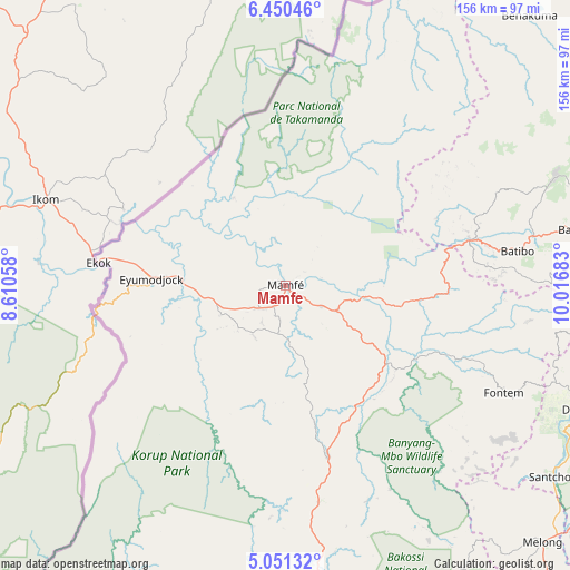
Mamfe GPS coordinates[2]
5° 45' 4.752" North, 9° 18' 49.32" East
| Map corner | latitude | longitude |
|---|---|---|
| Upper-left | 6.45046°, | 8.61058° |
| Center: | 5.75132°, | 9.3137° |
| Lower-right: | 5.05132°, | 10.01683° |
| Map W x H: | 155.6×155.6 km | = 96.7×96.7mi |
| max Lat: | 12.57535° ⇑32.8% North |
| Mamfe: | 5.75132° |
| min Lat: | ⇓67.2% South 2.35° |
| min Long | Mamfe | max Long |
| 8.8724° | 9.3137° | 15.23288° |
| W 3.3%⇐ | ⇒96.7% E |
Elevation
Elevation of Mamfe is 93 m = 305 ft, and this is 580.9 m = 1906 ft below average elevation for this country.
| Max E: |
1687 m = 5535 ft | 89.3% |
| Avg. | 673.9 m = 2211 ft | |
| Mamfe | 93 m = 305 ft | |
Min E: |
1 m = 3 ft | 10.7% |
See also: Cameroon elevation on elevation.city.
Geographical zone
Mamfe is located in North Torrid zone (between Equator and Tropic of Cancer). Distance of Equator is 639.5 km =397.4 mi to South.| Distance of | km | miles | from Mamfe |
|---|---|---|---|
| North Pole | 9367.6 | 5820.8 | to North |
| Arctic Circle | 6761.7 | 4201.5 | to North |
| Tropic Cancer | 1966.4 | 1221.9 | to North |
| Equator | 639.5 | 397.4 | to South |


Nearby cities:
15 places around Mamfe: (largest is in red/bold)
• Babanki
111.2 km =69.1 mi,  68°
68°
• Bali
78.7 km =48.9 mi,  78°
78°
• Bamenda
94.9 km =59 mi, 75°
• Batibo
60.6 km =37.7 mi, 81°
• Belo
111.9 km =69.5 mi, 67°
• Dschang
88.7 km =55.1 mi,  112°
112°
• Fontem
70.3 km =43.7 mi,  116°
116°
• Manjo
115.6 km =71.8 mi,  150°
150°
• Mbengwi
81.4 km =50.6 mi, 68°
• Mbouda
105 km =65.2 mi,  97°
97°
• Melong
100.2 km =62.3 mi,  134°
134°
• Mundemba
101.8 km =63.3 mi,  208°
208°
• Nguti
48.3 km =30 mi,  166°
166°
• Nkongsamba
112.5 km =69.9 mi,  141°
141°
• Wum
108.9 km =67.7 mi,  49°
49°
Sources, notices
• [Note1] Compared only with cities in Cameroon existing in our database
• [Src1] Map data: © OpenStreetMap contributors (CC-BY-SA)
• [Src2] Other city data from geonames.org with taken over terms of usage.
• [Src3] Geographical zone / Annual Mean Temperature by Robert A. Rohde @ Wikipedia
