Mbouda geodata
Mbouda (West) is a populated place; located in Cameroon in Africa/Douala (GMT+1) time zone. With population of 111,320 people, there are 14 cities with bigger population in this country. Compared to other cities in Cameroon, 65.6% of cities are located further ↓South; 68.9% of cities are located further →East and 92.6% of cities have lower elevation than Mbouda. Note1


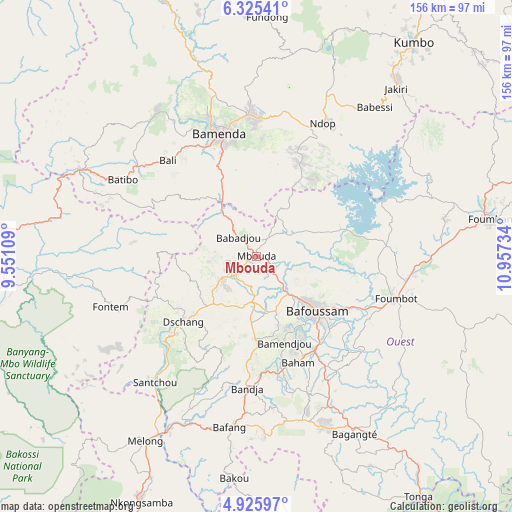
Mbouda GPS coordinates[2]
5° 37' 33.996" North, 10° 15' 15.156" East
| Map corner | latitude | longitude |
|---|---|---|
| Upper-left | 6.32541°, | 9.55109° |
| Center: | 5.62611°, | 10.25421° |
| Lower-right: | 4.92597°, | 10.95734° |
| Map W x H: | 155.6×155.6 km | = 96.7×96.7mi |
| max Lat: | 12.57535° ⇑34.4% North |
| Mbouda: | 5.62611° |
| min Lat: | ⇓65.6% South 2.35° |
| min Long | Mbouda | max Long |
| 8.8724° | 10.25421° | 15.23288° |
| W 31.1%⇐ | ⇒68.9% E |
Elevation
Elevation of Mbouda is 1416 m = 4646 ft, and this is 742.1 m = 2435 ft above average elevation for this country.
| Max E: |
1687 m = 5535 ft | 7.4% |
| Mbouda | 1416 m 4646 ft | |
| Avg. | 673.9 m = 2211 ft | |
Min E: |
1 m = 3 ft | 92.6% |
See also: Mbouda elevation on elevation.city.
Geographical zone
Mbouda is located in North Torrid zone (between Equator and Tropic of Cancer). Distance of Equator is 625.6 km =388.7 mi to South.| Distance of | km | miles | from Mbouda |
|---|---|---|---|
| North Pole | 9381.5 | 5829.4 | to North |
| Arctic Circle | 6775.6 | 4210.2 | to North |
| Tropic Cancer | 1980.4 | 1230.6 | to North |
| Equator | 625.6 | 388.7 | to South |


Nearby cities:
15 places around Mbouda: (largest is in red/bold)
• Babanki
54.5 km =33.9 mi,  359°
359°
• Bafang
52.8 km =32.8 mi,  189°
189°
• Bafoussam
24.5 km =15.2 mi,  132°
132°
• Bali
39.5 km =24.5 mi,  317°
317°
• Bamenda
39 km =24.2 mi,  342°
342°
• Bamendjou
27.6 km =17.1 mi,  162°
162°
• Bana
53.4 km =33.2 mi,  177°
177°
• Bandjoun
32.9 km =20.4 mi,  147°
147°
• Bansoa
20.8 km =12.9 mi, 161°
• Batibo
49.9 km =31 mi,  297°
297°
• Dschang
30.1 km =18.7 mi,  227°
227°
• Fontem
44.8 km =27.8 mi,  246°
246°
• Foumbot
43.9 km =27.3 mi,  107°
107°
• Mbengwi
51.7 km =32.1 mi,  327°
327°
• Ngou
49.9 km =31 mi, 163°
Sources, notices
• [Note1] Compared only with cities in Cameroon existing in our database
• [Src1] Map data: © OpenStreetMap contributors (CC-BY-SA)
• [Src2] Other city data from geonames.org with taken over terms of usage.
• [Src3] Geographical zone / Annual Mean Temperature by Robert A. Rohde @ Wikipedia
