Tiancheng geodata
Tiancheng (Hubei) is a seat of a third-order administrative division; located in China in Asia/Shanghai (GMT+8) time zone. In our database, there are 1268 cities with bigger population. Compared to other cities in China, 59.3% of cities are located further ↑North; 51.1% of cities are located further →East and 67.2% of cities have higher elevation than Tiancheng. Note1


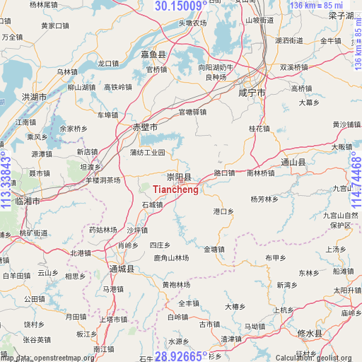
Tiancheng GPS coordinates[2]
29° 32' 24.792" North, 114° 2' 29.58" East
| Map corner | latitude | longitude |
|---|---|---|
| Upper-left | 30.15009°, | 113.33843° |
| Center: | 29.54022°, | 114.04155° |
| Lower-right: | 28.92665°, | 114.74468° |
| Map W x H: | 136×136 km | = 84.5×84.5mi |
| max Lat: | 53.31946° ⇑59.3% North |
| Tiancheng: | 29.54022° |
| min Lat: | ⇓40.7% South 18.22056° |
| min Long | Tiancheng | max Long |
| 75.07348° | 114.04155° | 134.28917° |
| W 48.9%⇐ | ⇒51.1% E |
Elevation
Elevation of Tiancheng is 64 m = 210 ft, and this is 420.8 m = 1381 ft below average elevation for this country.
| Max E: |
5622 m = 18445 ft | 67.2% |
| Avg. | 484.8 m = 1591 ft | |
| Tiancheng | 64 m = 210 ft | |
Min E: |
-3 m = -10 ft | 32.8% |
See also: China elevation on elevation.city.
Geographical zone
Tiancheng is located in North temperate zone (between Tropic of Cancer and the Arctic Circle). Distance of this Northern Tropic circle is 678.6 km =421.7 mi to South.| Distance of | km | miles | from Tiancheng |
|---|---|---|---|
| North Pole | 6722.5 | 4177.2 | to North |
| Arctic Circle | 4116.6 | 2557.9 | to North |
| Tropic Cancer | 678.6 | 421.7 | to South |
| Equator | 3284.6 | 2041 | to South |


Nearby cities:
15 places around Tiancheng: (largest is in red/bold)
• Baini
8.5 km =5.3 mi,  93°
93°
• Cha’anling
26.5 km =16.5 mi,  292°
292°
• Gangkou
19.1 km =11.9 mi,  125°
125°
• Guantangyi
26.5 km =16.5 mi,  9°
9°
• Guihuaquan
16.4 km =10.2 mi,  277°
277°
• Jintang
28.1 km =17.5 mi,  153°
153°
• Lukou
16.3 km =10.1 mi,  77°
77°
• Puqi
24.9 km =15.5 mi,  322°
322°
• Qingshan
11.5 km =7.1 mi,  190°
190°
• Shaping
24.6 km =15.3 mi,  222°
222°
• Shicheng
13.9 km =8.6 mi,  233°
233°
• Sizhuang
25.7 km =16 mi,  200°
200°
• Tongzhong
9.5 km =5.9 mi,  138°
138°
• Yangloudong
28.8 km =17.9 mi,  270°
270°
• Zhonghuopu
24.8 km =15.4 mi,  350°
350°
Sources, notices
• [Note1] Compared only with cities in China existing in our database
• [Src1] Map data: © OpenStreetMap contributors (CC-BY-SA)
• [Src2] Other city data from geonames.org with taken over terms of usage.
• [Src3] Geographical zone / Annual Mean Temperature by Robert A. Rohde @ Wikipedia
