Lukou geodata
Lukou (Hubei) is a seat of a fourth-order administrative division; located in China in Asia/Shanghai (GMT+8) time zone. In our database, there are 1268 cities with bigger population. Compared to other cities in China, 58.9% of cities are located further ↑North; 50.1% of cities are located further →East and 56.9% of cities have higher elevation than Lukou. Note1


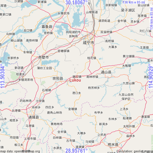
Lukou GPS coordinates[2]
29° 34' 15.564" North, 114° 12' 22.176" East
| Map corner | latitude | longitude |
|---|---|---|
| Upper-left | 30.18067°, | 113.50304° |
| Center: | 29.57099°, | 114.20616° |
| Lower-right: | 28.95761°, | 114.90929° |
| Map W x H: | 136×136 km | = 84.5×84.5mi |
| max Lat: | 53.31946° ⇑58.9% North |
| Lukou: | 29.57099° |
| min Lat: | ⇓41.1% South 18.22056° |
| min Long | Lukou | max Long |
| 75.07348° | 114.20616° | 134.28917° |
| W 49.9%⇐ | ⇒50.1% E |
Elevation
Elevation of Lukou is 118 m = 387 ft, and this is 366.8 m = 1203 ft below average elevation for this country.
| Max E: |
5622 m = 18445 ft | 56.9% |
| Avg. | 484.8 m = 1591 ft | |
| Lukou | 118 m = 387 ft | |
Min E: |
-3 m = -10 ft | 43.1% |
See also: China elevation on elevation.city.
Geographical zone
Lukou is located in North temperate zone (between Tropic of Cancer and the Arctic Circle). Distance of this Northern Tropic circle is 682.1 km =423.8 mi to South.| Distance of | km | miles | from Lukou |
|---|---|---|---|
| North Pole | 6719.1 | 4175.1 | to North |
| Arctic Circle | 4113.2 | 2555.8 | to North |
| Tropic Cancer | 682.1 | 423.8 | to South |
| Equator | 3288 | 2043.1 | to South |


Nearby cities:
15 places around Lukou: (largest is in red/bold)
• Baini
8.4 km =5.2 mi,  241°
241°
• Dalu
22 km =13.7 mi,  81°
81°
• Gangkou
14.6 km =9.1 mi,  181°
181°
• Guantangyi
25.5 km =15.8 mi,  332°
332°
• Guihua
21.1 km =13.1 mi,  39°
39°
• Jintang
28.8 km =17.9 mi,  186°
186°
• Nanlinqiao
13.8 km =8.6 mi,  89°
89°
• Qingshan
23.3 km =14.5 mi,  230°
230°
• Shicheng
29.5 km =18.3 mi,  246°
246°
• Tiancheng
16.3 km =10.1 mi,  257°
257°
• Tingsiqiao
27.6 km =17.1 mi,  352°
352°
• Tongzhong
14.3 km =8.9 mi,  222°
222°
• Xiapu
25.7 km =16 mi,  104°
104°
• Yangfanglin
18 km =11.2 mi,  122°
122°
• Zhonghuopu
28.9 km =18 mi,  316°
316°
Sources, notices
• [Note1] Compared only with cities in China existing in our database
• [Src1] Map data: © OpenStreetMap contributors (CC-BY-SA)
• [Src2] Other city data from geonames.org with taken over terms of usage.
• [Src3] Geographical zone / Annual Mean Temperature by Robert A. Rohde @ Wikipedia
