Zhijiang geodata
Zhijiang (Hunan) is a seat of a third-order administrative division; located in China in Asia/Shanghai (GMT+8) time zone. In our database, there are 1268 cities with bigger population. Compared to other cities in China, 76.8% of cities are located further ↑North; 73% of cities are located further →East and 60.6% of cities have lower elevation than Zhijiang. Note1


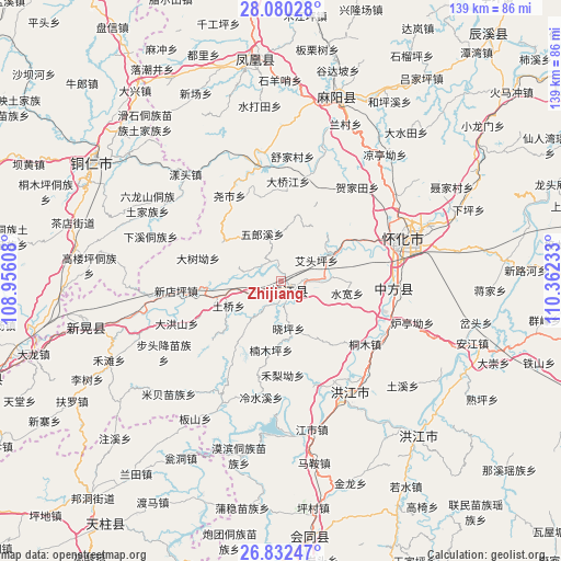
Zhijiang GPS coordinates[2]
27° 27' 29.304" North, 109° 39' 33.12" East
| Map corner | latitude | longitude |
|---|---|---|
| Upper-left | 28.08028°, | 108.95608° |
| Center: | 27.45814°, | 109.6592° |
| Lower-right: | 26.83247°, | 110.36233° |
| Map W x H: | 138.7×138.7 km | = 86.2×86.2mi |
| max Lat: | 53.31946° ⇑76.8% North |
| Zhijiang: | 27.45814° |
| min Lat: | ⇓23.2% South 18.22056° |
| min Long | Zhijiang | max Long |
| 75.07348° | 109.6592° | 134.28917° |
| W 27%⇐ | ⇒73% E |
Elevation
Elevation of Zhijiang is 267 m = 876 ft, and this is 217.8 m = 715 ft below average elevation for this country.
| Max E: |
5622 m = 18445 ft | 39.4% |
| Avg. | 484.8 m = 1591 ft | |
| Zhijiang | 267 m = 876 ft | |
Min E: |
-3 m = -10 ft | 60.6% |
See also: China elevation on elevation.city.
Geographical zone
Zhijiang is located in North temperate zone (between Tropic of Cancer and the Arctic Circle). Distance of this Northern Tropic circle is 447.1 km =277.8 mi to South.| Distance of | km | miles | from Zhijiang |
|---|---|---|---|
| North Pole | 6954 | 4321 | to North |
| Arctic Circle | 4348.1 | 2701.8 | to North |
| Tropic Cancer | 447.1 | 277.8 | to South |
| Equator | 3053.1 | 1897.1 | to South |


Nearby cities:
15 places around Zhijiang: (largest is in red/bold)
• Biyong
33.5 km =20.8 mi,  206°
206°
• Huaihua
36 km =22.4 mi,  71°
71°
• Huangjin’ao
35.9 km =22.3 mi,  52°
52°
• Jiangkouxu
27.3 km =17 mi,  16°
16°
• Jinhe
29.3 km =18.2 mi,  349°
349°
• Luojiu
16.1 km =10 mi, 66°
• Nanmuping
16.5 km =10.3 mi,  173°
173°
• Pailou’ao
28.7 km =17.8 mi,  117°
117°
• Qiancheng
32.1 km =19.9 mi,  160°
160°
• Shuangxi
32.1 km =19.9 mi,  142°
142°
• Tuokou
37.2 km =23.1 mi,  185°
185°
• Xiaoping
11.6 km =7.2 mi,  154°
154°
• Yangtou
35.3 km =21.9 mi,  316°
316°
• Yaoshi
23.8 km =14.8 mi,  327°
327°
• Zhongfang
27.4 km =17 mi,  100°
100°
Sources, notices
• [Note1] Compared only with cities in China existing in our database
• [Src1] Map data: © OpenStreetMap contributors (CC-BY-SA)
• [Src2] Other city data from geonames.org with taken over terms of usage.
• [Src3] Geographical zone / Annual Mean Temperature by Robert A. Rohde @ Wikipedia
