Yangtou geodata
Yangtou (Guizhou) is a populated place; located in China in Asia/Shanghai (GMT+8) time zone. With population of 1,145 people, there are 1146 cities with bigger population in this country. Compared to other cities in China, 75.8% of cities are located further ↑North; 74.4% of cities are located further →East and 63.3% of cities have lower elevation than Yangtou. Note1


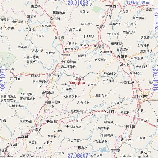
Yangtou GPS coordinates[2]
27° 41' 21.984" North, 109° 24' 50.004" East
| Map corner | latitude | longitude |
|---|---|---|
| Upper-left | 28.31026°, | 108.71077° |
| Center: | 27.68944°, | 109.41389° |
| Lower-right: | 27.06507°, | 110.11702° |
| Map W x H: | 138.5×138.5 km | = 86.1×86.1mi |
| max Lat: | 53.31946° ⇑75.8% North |
| Yangtou: | 27.68944° |
| min Lat: | ⇓24.2% South 18.22056° |
| min Long | Yangtou | max Long |
| 75.07348° | 109.41389° | 134.28917° |
| W 25.6%⇐ | ⇒74.4% E |
Elevation
Elevation of Yangtou is 302 m = 991 ft, and this is 182.8 m = 600 ft below average elevation for this country.
| Max E: |
5622 m = 18445 ft | 36.7% |
| Avg. | 484.8 m = 1591 ft | |
| Yangtou | 302 m = 991 ft | |
Min E: |
-3 m = -10 ft | 63.3% |
See also: China elevation on elevation.city.
Geographical zone
Yangtou is located in North temperate zone (between Tropic of Cancer and the Arctic Circle). Distance of this Northern Tropic circle is 472.9 km =293.8 mi to South.| Distance of | km | miles | from Yangtou |
|---|---|---|---|
| North Pole | 6928.3 | 4305 | to North |
| Arctic Circle | 4322.4 | 2685.8 | to North |
| Tropic Cancer | 472.9 | 293.8 | to South |
| Equator | 3078.8 | 1913.1 | to South |


Nearby cities:
15 places around Yangtou: (largest is in red/bold)
• Banpan
35.1 km =21.8 mi,  358°
358°
• Chadian
30.2 km =18.8 mi,  246°
246°
• Chatian
13.2 km =8.2 mi,  342°
342°
• Chuandong
22.9 km =14.2 mi,  304°
304°
• Fenghuang
32.9 km =20.4 mi,  33°
33°
• Jiangkouxu
31.7 km =19.7 mi,  89°
89°
• Jinhe
19 km =11.8 mi,  80°
80°
• Mulong
34.2 km =21.3 mi,  277°
277°
• Shuidatian
26.1 km =16.2 mi,  46°
46°
• Tongren
22.7 km =14.1 mi, 277°
• Tuojiang
33.2 km =20.6 mi, 27°
• Wanshan
27.6 km =17.1 mi,  227°
227°
• Yaoshi
12.7 km =7.9 mi,  115°
115°
• Youyupu
31.5 km =19.6 mi,  240°
240°
• Zhijiang
35.3 km =21.9 mi,  136°
136°
Sources, notices
• [Note1] Compared only with cities in China existing in our database
• [Src1] Map data: © OpenStreetMap contributors (CC-BY-SA)
• [Src2] Other city data from geonames.org with taken over terms of usage.
• [Src3] Geographical zone / Annual Mean Temperature by Robert A. Rohde @ Wikipedia
