Jiangkouxu geodata
Jiangkouxu (Hunan) is a populated place; located in China in Asia/Shanghai (GMT+8) time zone. With population of 1,450 people, there are 1098 cities with bigger population in this country. Compared to other cities in China, 75.8% of cities are located further ↑North; 72.6% of cities are located further →East and 51.1% of cities have lower elevation than Jiangkouxu. Note1


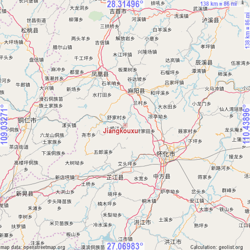
Jiangkouxu GPS coordinates[2]
27° 41' 39.012" North, 109° 44' 8.988" East
| Map corner | latitude | longitude |
|---|---|---|
| Upper-left | 28.31496°, | 109.03271° |
| Center: | 27.69417°, | 109.73583° |
| Lower-right: | 27.06983°, | 110.43896° |
| Map W x H: | 138.4×138.4 km | = 86×86mi |
| max Lat: | 53.31946° ⇑75.8% North |
| Jiangkouxu: | 27.69417° |
| min Lat: | ⇓24.2% South 18.22056° |
| min Long | Jiangkouxu | max Long |
| 75.07348° | 109.73583° | 134.28917° |
| W 27.4%⇐ | ⇒72.6% E |
Elevation
Elevation of Jiangkouxu is 174 m = 571 ft, and this is 310.8 m = 1020 ft below average elevation for this country.
| Max E: |
5622 m = 18445 ft | 48.9% |
| Avg. | 484.8 m = 1591 ft | |
| Jiangkouxu | 174 m = 571 ft | |
Min E: |
-3 m = -10 ft | 51.1% |
See also: China elevation on elevation.city.
Geographical zone
Jiangkouxu is located in North temperate zone (between Tropic of Cancer and the Arctic Circle). Distance of this Northern Tropic circle is 473.4 km =294.2 mi to South.| Distance of | km | miles | from Jiangkouxu |
|---|---|---|---|
| North Pole | 6927.8 | 4304.7 | to North |
| Arctic Circle | 4321.9 | 2685.5 | to North |
| Tropic Cancer | 473.4 | 294.2 | to South |
| Equator | 3079.3 | 1913.4 | to South |


Nearby cities:
15 places around Jiangkouxu: (largest is in red/bold)
• Fenghuang
30 km =18.6 mi,  333°
333°
• Gaocun
20.9 km =13 mi,  13°
13°
• Huaihua
30.2 km =18.8 mi,  118°
118°
• Huangjin’ao
21.5 km =13.4 mi,  102°
102°
• Jinhe
13.2 km =8.2 mi,  281°
281°
• Lanli
28 km =17.4 mi,  39°
39°
• Luojiu
21.1 km =13.1 mi,  160°
160°
• Luyang
36.6 km =22.7 mi, 102°
• Shuidatian
21.8 km =13.5 mi,  323°
323°
• Tuojiang
33.3 km =20.7 mi, 330°
• Xiaoping
36.7 km =22.8 mi,  183°
183°
• Yangtou
31.7 km =19.7 mi,  269°
269°
• Yanmen
17.9 km =11.1 mi,  1°
1°
• Yaoshi
21.1 km =13.1 mi,  253°
253°
• Zhijiang
27.3 km =17 mi,  196°
196°
Sources, notices
• [Note1] Compared only with cities in China existing in our database
• [Src1] Map data: © OpenStreetMap contributors (CC-BY-SA)
• [Src2] Other city data from geonames.org with taken over terms of usage.
• [Src3] Geographical zone / Annual Mean Temperature by Robert A. Rohde @ Wikipedia
