Nanmuping geodata
Nanmuping (Hunan) is a populated place; located in China in Asia/Shanghai (GMT+8) time zone. With population of 1,320 people, there are 1120 cities with bigger population in this country. Compared to other cities in China, 77.4% of cities are located further ↑North; 72.9% of cities are located further →East and 67% of cities have lower elevation than Nanmuping. Note1


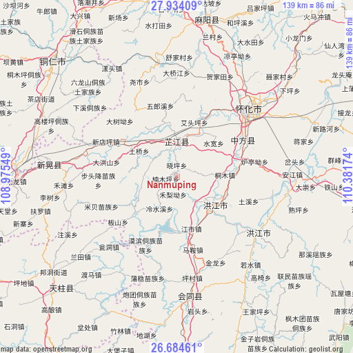
Nanmuping GPS coordinates[2]
27° 18' 39.996" North, 109° 40' 42.996" East
| Map corner | latitude | longitude |
|---|---|---|
| Upper-left | 27.93409°, | 108.97549° |
| Center: | 27.31111°, | 109.67861° |
| Lower-right: | 26.68461°, | 110.38174° |
| Map W x H: | 138.9×138.9 km | = 86.3×86.3mi |
| max Lat: | 53.31946° ⇑77.4% North |
| Nanmuping: | 27.31111° |
| min Lat: | ⇓22.6% South 18.22056° |
| min Long | Nanmuping | max Long |
| 75.07348° | 109.67861° | 134.28917° |
| W 27.1%⇐ | ⇒72.9% E |
Elevation
Elevation of Nanmuping is 359 m = 1178 ft, and this is 125.8 m = 413 ft below average elevation for this country.
| Max E: |
5622 m = 18445 ft | 33% |
| Avg. | 484.8 m = 1591 ft | |
| Nanmuping | 359 m = 1178 ft | |
Min E: |
-3 m = -10 ft | 67% |
See also: China elevation on elevation.city.
Geographical zone
Nanmuping is located in North temperate zone (between Tropic of Cancer and the Arctic Circle). Distance of this Northern Tropic circle is 430.8 km =267.7 mi to South.| Distance of | km | miles | from Nanmuping |
|---|---|---|---|
| North Pole | 6970.4 | 4331.2 | to North |
| Arctic Circle | 4364.5 | 2712 | to North |
| Tropic Cancer | 430.8 | 267.7 | to South |
| Equator | 3036.7 | 1886.9 | to South |


Nearby cities:
15 places around Nanmuping: (largest is in red/bold)
• Biyong
21.6 km =13.4 mi,  230°
230°
• Hongjiang
38.5 km =23.9 mi,  125°
125°
• Jiangshi
21.7 km =13.5 mi,  164°
164°
• Luojiu
26.1 km =16.2 mi,  29°
29°
• Mibei
31.9 km =19.8 mi,  248°
248°
• Mobin Tongzumiaozuxiang
29.8 km =18.5 mi,  204°
204°
• Pailou’ao
23.9 km =14.9 mi,  82°
82°
• Puzi
37.4 km =23.2 mi,  165°
165°
• Qiancheng
16.4 km =10.2 mi,  148°
148°
• Shawan
36.7 km =22.8 mi,  109°
109°
• Shuangxi
19.8 km =12.3 mi,  117°
117°
• Tuokou
21.4 km =13.3 mi,  194°
194°
• Xiaoping
6.7 km =4.2 mi, 28°
• Zhijiang
16.5 km =10.3 mi,  353°
353°
• Zhongfang
27.4 km =17 mi,  65°
65°
Sources, notices
• [Note1] Compared only with cities in China existing in our database
• [Src1] Map data: © OpenStreetMap contributors (CC-BY-SA)
• [Src2] Other city data from geonames.org with taken over terms of usage.
• [Src3] Geographical zone / Annual Mean Temperature by Robert A. Rohde @ Wikipedia
