Huangjin’ao geodata
Huangjin’ao (Hunan) is a populated place; located in China in Asia/Shanghai (GMT+8) time zone. With population of 830 people, there are 1211 cities with bigger population in this country. Compared to other cities in China, 76% of cities are located further ↑North; 71.5% of cities are located further →East and 60.6% of cities have lower elevation than Huangjin’ao. Note1


Huangjin’ao GPS coordinates[2]
27° 39' 11.988" North, 109° 56' 57.012" East
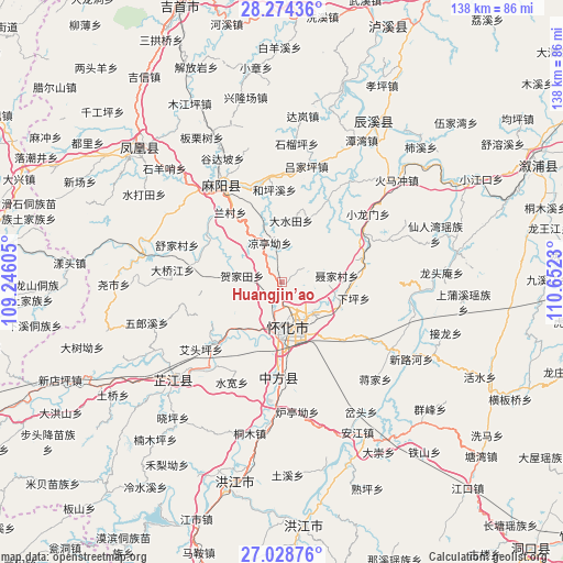
| Map corner | latitude | longitude |
|---|---|---|
| Upper-left | 28.27436°, | 109.24605° |
| Center: | 27.65333°, | 109.94917° |
| Lower-right: | 27.02876°, | 110.6523° |
| Map W x H: | 138.5×138.5 km | = 86.1×86.1mi |
| max Lat: | 53.31946° ⇑76% North |
| Huangjin’ao: | 27.65333° |
| min Lat: | ⇓24% South 18.22056° |
| min Long | Huangjin’ao | max Long |
| 75.07348° | 109.94917° | 134.28917° |
| W 28.5%⇐ | ⇒71.5% E |
Elevation
Elevation of Huangjin’ao is 267 m = 876 ft, and this is 217.8 m = 715 ft below average elevation for this country.
| Max E: |
5622 m = 18445 ft | 39.4% |
| Avg. | 484.8 m = 1591 ft | |
| Huangjin’ao | 267 m = 876 ft | |
Min E: |
-3 m = -10 ft | 60.6% |
See also: China elevation on elevation.city.
Geographical zone
Huangjin’ao is located in North temperate zone (between Tropic of Cancer and the Arctic Circle). Distance of this Northern Tropic circle is 468.8 km =291.3 mi to South.| Distance of | km | miles | from Huangjin’ao |
|---|---|---|---|
| North Pole | 6932.3 | 4307.5 | to North |
| Arctic Circle | 4326.4 | 2688.3 | to North |
| Tropic Cancer | 468.8 | 291.3 | to South |
| Equator | 3074.8 | 1910.6 | to South |


Nearby cities:
15 places around Huangjin’ao: (largest is in red/bold)
• Anping
28.8 km =17.9 mi,  34°
34°
• Gaocun
29.7 km =18.5 mi,  326°
326°
• Huaihua
11.4 km =7.1 mi,  151°
151°
• Huaqiao
19.9 km =12.4 mi,  72°
72°
• Jiangkouxu
21.5 km =13.4 mi,  282°
282°
• Jinhe
34.6 km =21.5 mi, 281°
• Lanli
26.1 km =16.2 mi,  353°
353°
• Luojiu
20.6 km =12.8 mi,  222°
222°
• Luyang
15.1 km =9.4 mi,  102°
102°
• Pailou’ao
34.9 km =21.7 mi,  184°
184°
• Tongwan
33.3 km =20.7 mi, 103°
• Xiaolongmen
26.6 km =16.5 mi,  51°
51°
• Yanmen
30.4 km =18.9 mi,  317°
317°
• Zhijiang
35.9 km =22.3 mi,  232°
232°
• Zhongfang
27 km =16.8 mi, 183°
Sources, notices
• [Note1] Compared only with cities in China existing in our database
• [Src1] Map data: © OpenStreetMap contributors (CC-BY-SA)
• [Src2] Other city data from geonames.org with taken over terms of usage.
• [Src3] Geographical zone / Annual Mean Temperature by Robert A. Rohde @ Wikipedia
